IMAGES TAKEN NEAR TO
Balmoral Road, LIVERPOOL, L6 8ND
Introduction
This page details the photographs taken nearby to Balmoral Road, L6 8ND by members of the Geograph project.
The Geograph project started in 2005 with the aim of publishing, organising and preserving representative images for every square kilometre of Great Britain, Ireland and the Isle of Man.

There are currently over 7.5m images from over14,400 individuals and you can help contribute to the project by visiting https://www.geograph.org.uk
Image Map
Images are licensed for reuse under creativecommons.org/licenses/by-sa/2.0
Notes
- Clicking on the map will re-center to the selected point.
- The higher the marker number, the further away the image location is from the centre of the postcode.
Image Listing (5 Images Found)
Images are licensed for reuse under creativecommons.org/licenses/by-sa/2.0
Image
Details
Distance
3
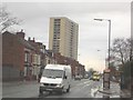
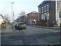
Sheil Road
These flats have gone now, returning the victorian road to what it looked like 30 years ago
Image: © russ
Taken: Unknown
0.16 miles
4
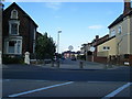
St Philip and St David church, Sheil Road
Architect Bruxby & Evans. 1976.
Image: © S Parish
Taken: 20 May 2008
0.19 miles
5
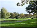
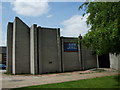
Newsham Park
Newsham Park was the first of the celebrated trio of new parks developed to ring Victorian Liverpool. The park, which was based on designs by Edward Kemp, may represent Kemp's first solo venture in public park design. It is surrounded by fine period architecture which was developed to fund the park layout in 1866 and includes the grade II listed Seaman's Orphanage and Newsham House. The latter is the 'sumptuous mansion' where Queen Victoria stayed in 1886 and which is still in use as the 'Judge's' Lodgings.
Image: © Sue Adair
Taken: 31 Oct 2005
0.24 miles