IMAGES TAKEN NEAR TO
L65 6TG
Introduction
This page details the photographs taken nearby to L65 6TG by members of the Geograph project.
The Geograph project started in 2005 with the aim of publishing, organising and preserving representative images for every square kilometre of Great Britain, Ireland and the Isle of Man.

There are currently over 7.5m images from over14,400 individuals and you can help contribute to the project by visiting https://www.geograph.org.uk
Image Map
Images are licensed for reuse under creativecommons.org/licenses/by-sa/2.0
Notes
- Clicking on the map will re-center to the selected point.
- The higher the marker number, the further away the image location is from the centre of the postcode.
Image Listing (10 Images Found)
Images are licensed for reuse under creativecommons.org/licenses/by-sa/2.0
Image
Details
Distance
1
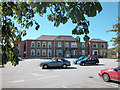
Cottage Hospital
Part of a larger hospital complex.
Image: © Dennis Turner
Taken: 7 Aug 2005
0.00 miles
3
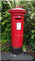
George V postbox on Chester Road, Ellesmere Port
Postbox No. CH65 484.
Image: © JThomas
Taken: 15 Jun 2019
0.18 miles
6

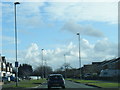
Sign for the Woodland, Ellesmere Port
Image: © JThomas
Taken: 15 Jun 2019
0.24 miles
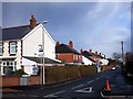
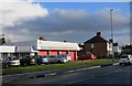
7
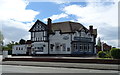
The Woodland, Ellesmere Port
Sizzling Pub & Grill on Chester Road.
Image: © JThomas
Taken: 15 Jun 2019
0.24 miles
8
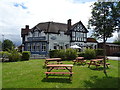
The Woodland, Ellesmere Port
Sizzling Pub & Grill on Chester Road.
Image: © JThomas
Taken: 15 Jun 2019
0.24 miles
9
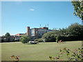
Whitby School
Started life as Ellesmere Port Grammar School for Boys.
Image: © Dennis Turner
Taken: 7 Aug 2005
0.25 miles
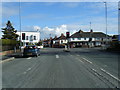
10
Ellesmere Service Centre
Auto business on Chester Road.
Image: © Des Blenkinsopp
Taken: 24 Feb 2015
0.25 miles