IMAGES TAKEN NEAR TO
West Derby Road, LIVERPOOL, L6 4BR
Introduction
This page details the photographs taken nearby to West Derby Road, L6 4BR by members of the Geograph project.
The Geograph project started in 2005 with the aim of publishing, organising and preserving representative images for every square kilometre of Great Britain, Ireland and the Isle of Man.

There are currently over 7.5m images from over14,400 individuals and you can help contribute to the project by visiting https://www.geograph.org.uk
Image Map
Images are licensed for reuse under creativecommons.org/licenses/by-sa/2.0
Notes
- Clicking on the map will re-center to the selected point.
- The higher the marker number, the further away the image location is from the centre of the postcode.
Image Listing (32 Images Found)
Images are licensed for reuse under creativecommons.org/licenses/by-sa/2.0
Image
Details
Distance
1
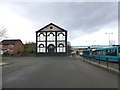
New Road Church on West Derby Road
Bootle Branch railway bridge in background
Image: © Raymond Knapman
Taken: 18 Feb 2014
0.04 miles
2
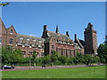
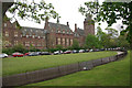
The Liverpool Seamen's Orphan Institution, Newsham Park
Image: © Sue Adair
Taken: 30 May 2009
0.10 miles
3
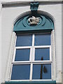
Derby Hall Tuebrook
Derby Hall above Tuebrook Post Office on West Derby Road, close up showing the eagle and child crest of the Earls of Derby and the date 1875 when it was built as a Masonic Hall. Marlborough Lodge No.1620, had its warrant issued on 20th May 1876, the first meetings were held in Marlborough Terrace, Tuebrook, from whence the lodge took its name, with the Lodge consecration being held on 10th September. On 5th April 1904 the lodge left Derby Hall for the Masonic Hall in Hope Street. It became a billiard hall in the 1930's, Ogden's Social Club in the 1960's and then a community hall.
Image: © Sue Adair
Taken: 4 Jul 2011
0.11 miles
4
Newsham Park beside Newsham Drive, Liverpool
Image: © Mike Pennington
Taken: 22 Oct 2015
0.11 miles
5
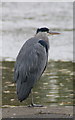
Grey Heron (Ardea cinerea), Newsham Park, Liverpool
Like many park herons, this individual has become habituated to human presence, allowing much closer approach than birds in wilder habitats.
Image: © Mike Pennington
Taken: 22 Oct 2015
0.13 miles
6
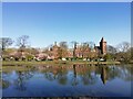
Newsham Park Hospital across the Lake
Newsham Park Hospital is a grade II listed building previously The Liverpool Seamen's Orphan Institution.
Image: © Sue Adair
Taken: 15 Apr 2021
0.13 miles
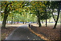
7

Newsham Park
A riot of dandelions at the northern end of this 121 acre Victorian park with houses on Newsham Drive seen through the trees.
Image: © Stephen McKay
Taken: 19 May 2013
0.14 miles
8

Newsham Park
This 121 acre park was opened in 1868. The boating lake seen here, the larger of two lakes in the park, no longer has boats but is evidently well used by fishermen.
Image: © Stephen McKay
Taken: 19 May 2013
0.14 miles
9
Newsham Park Hospital
This grade II listed building on Orphan Drive to the east of Newsham Park opened in 1874 as the Liverpool Seamen's Orphan Institution. By 1899 321 children were accommodated here and in 1900 a swimming pool was added. However, numbers declined after World War II and the orphanage closed in 1949. The building was sold to the Ministry of Health in 1951 and served as a general and psychiatric hospital until 1988 since when it has lain boarded up and abandoned, looking very unloved. A proposal to turn it into flats a few years ago fell through and the building faces an uncertain future.
Image: © Stephen McKay
Taken: 19 May 2013
0.15 miles
10
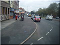
West Derby Road
Viewed from the junction of Lower Breck Road.
Image: © Colin Pyle
Taken: 15 Oct 2009
0.15 miles