IMAGES TAKEN NEAR TO
Lavan Close, LIVERPOOL, L6 2WQ
Introduction
This page details the photographs taken nearby to Lavan Close, L6 2WQ by members of the Geograph project.
The Geograph project started in 2005 with the aim of publishing, organising and preserving representative images for every square kilometre of Great Britain, Ireland and the Isle of Man.

There are currently over 7.5m images from over14,400 individuals and you can help contribute to the project by visiting https://www.geograph.org.uk
Image Map (Loading...)


Getting Data...Please wait
Leaflet Map data © OpenStreetMap
Images are licensed for reuse under creativecommons.org/licenses/by-sa/2.0
Notes
- Clicking on the map will re-center to the selected point.
- The higher the marker number, the further away the image location is from the centre of the postcode.
Image Listing (41 Images Found)
Images are licensed for reuse under creativecommons.org/licenses/by-sa/2.0
Image
Details
Distance
1
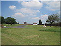
Liverpool Necropolis - Grant Gardens
Due to the expansion of the port of Liverpool in the early 18th century Liverpool Necropolis (Low Hill Cemetery) was opened 1825, at the corner of Everton Road and West Derby Road (formerly Rake Lane). Designed by Architect John Foster Jr.at a cost of £8,000, the much needed cemetery was rapidly filled in the following 70 years with 80,000 burials. It was closed to burials in 1898 and in 1913 the lodges, gates & walls were demolished, monuments and large gravestones removed and the area landscaped.
Grant Gardens were opened by Alderman J R Grant in 1914.
See photos and more info: http://www.thescousehouse.net/index.php?showtopic=10306
Image: © Sue Adair
Taken: 2 Jul 2011
0.07 miles
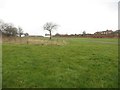
2
Grant Gardens, Liverpool
Grant Gardens is a park on the site of a former cemetery (Liverpool Necropolis/Low Hill Cemetery).
The Necropolis opened in 1825 but was closed by the council in 1898 because of unsanitary conditions spreading to surrounding neighbourhoods (Grant Gardens. (2022, October 19). In Wikipedia. https://en.wikipedia.org/wiki/Grant_Gardens ) as it was nearing its full capacity of 80,000 burials. It was reopened as a public park in 1914; memorials and structures above ground have been removed, the graves themselves are intact.
Image: © David Dixon
Taken: 6 Sep 2022
0.07 miles
3
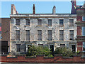
Brougham Terrace, West Derby Road, Liverpool
Georgian elegance and refined proportions shine through even the most peeling facade I think I have ever seen. Built c1830 by J.A. Picton, it once boasted twelve houses. Grade II listed.
The listing states that from 1887 it is believed to have housed England's first mosque. The neighbouring building may still be a mosque, but this looks in desperate need of several licks of paint.
Image: © Stephen Richards
Taken: 26 Jul 2011
0.08 miles
4

Low Hill fire station
Low Hill fire station, West Derby Road, Liverpool
Image: © Kevin Hale
Taken: 27 May 2010
0.08 miles
5
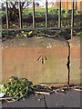
Bench mark in West Derby Road outside Grant Gardens
This Ordnance Survey bench mark is on the perimeter wall of Grant Gardens (formerly the Necropolis http://www.toxtethparkcemetery.co.uk/Necropolis%20Web%20Home%20Page.html ) near its south east corner in West Derby Road.
Image: © John S Turner
Taken: 28 Jan 2012
0.08 miles
6
Grant Gardens, Liverpool
A grassed park in Liverpool.
Image: © Graham Robson
Taken: 13 Mar 2016
0.08 miles
7
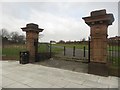
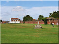
Entrance to Grant Gardens, Liverpool
The ornate entrance gateway into Grant Gardens. Until the late 19th Century this was a large non-conformist cemetery, it closed having reached capacity.
Image: © Graham Robson
Taken: 13 Mar 2016
0.09 miles
8

Everton Road approaching Brunswick Road
Image: © Mark Anderson
Taken: 29 Oct 2024
0.10 miles
9
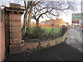
The southwest corner of Grant Gardens perimeter wall
The southwest corner of Grant Gardens perimeter wall in Everton Road. (Grant Gardens was formerly the Necropolis http://www.toxtethparkcemetery.co.uk/Necropolis%20Web%20Home%20Page.html ) There is an Ordnance Survey pivot bench mark on the low wall to the right of the stone pillar - Image
Image: © John S Turner
Taken: 28 Jan 2012
0.10 miles
10
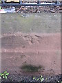
Pivot bench mark in Everton Road outside Grant Gardens
This Ordnance Survey pivot bench mark is on the perimeter wall of Grant Gardens (formerly the Necropolis http://www.toxtethparkcemetery.co.uk/Necropolis%20Web%20Home%20Page.html ) near its south west corner in Everton Road. See also Image
Image: © John S Turner
Taken: 28 Jan 2012
0.10 miles