IMAGES TAKEN NEAR TO
Margaret Street, LIVERPOOL, L6 2AX
Introduction
This page details the photographs taken nearby to Margaret Street, L6 2AX by members of the Geograph project.
The Geograph project started in 2005 with the aim of publishing, organising and preserving representative images for every square kilometre of Great Britain, Ireland and the Isle of Man.

There are currently over 7.5m images from over14,400 individuals and you can help contribute to the project by visiting https://www.geograph.org.uk
Image Map
Images are licensed for reuse under creativecommons.org/licenses/by-sa/2.0
Notes
- Clicking on the map will re-center to the selected point.
- The higher the marker number, the further away the image location is from the centre of the postcode.
Image Listing (52 Images Found)
Images are licensed for reuse under creativecommons.org/licenses/by-sa/2.0
Image
Details
Distance
2
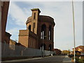
Everton Water Tower
When the old Liverpool Corporation Waterworks built the water tower on the top of Everton Hill in 1856 they created a sandstone masterpiece that dominates the area to this day. It still performs a vital role the city's water distribution system. Designed by the Liverpool's first water engineer, Thomas Duncan, it is all that is visible of the one and a half acre 12 feet deep water service reservoir. The local red sandstone hides a cast iron tank 90 feet above ground level
Image: © Sue Adair
Taken: 31 Oct 2005
0.11 miles
3
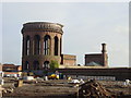
Everton Water works
Fine pumping engine houses and a water tower with a cast iron tank supported on a magnificent stone structure. A fine example of municipal architecture.
According to Peter Cahill, who has contacted me, the chimney-like structure adjacent to the water tower contained a stand-pipe and stairs and has had its top section removed. The other square structure is a chimney and Peter thinks it has not been shortened. There is apparently a contemporary engraving in the Illustrated Times of 1856.
Image: © Chris Allen
Taken: 9 Aug 1987
0.11 miles
5
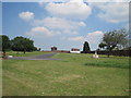
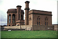
Liverpool Necropolis - Grant Gardens
Due to the expansion of the port of Liverpool in the early 18th century Liverpool Necropolis (Low Hill Cemetery) was opened 1825, at the corner of Everton Road and West Derby Road (formerly Rake Lane). Designed by Architect John Foster Jr.at a cost of £8,000, the much needed cemetery was rapidly filled in the following 70 years with 80,000 burials. It was closed to burials in 1898 and in 1913 the lodges, gates & walls were demolished, monuments and large gravestones removed and the area landscaped.
Grant Gardens were opened by Alderman J R Grant in 1914.
See photos and more info: http://www.thescousehouse.net/index.php?showtopic=10306
Image: © Sue Adair
Taken: 2 Jul 2011
0.13 miles
7
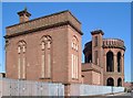
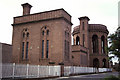
Water works, Margaret Street, Liverpool
These 1857 buildings are also shown in http://www.geograph.org.uk/search.php?i=40170751 . See https://historicengland.org.uk/listing/the-list/list-entry/1208230 and https://historicengland.org.uk/listing/the-list/list-entry/1070630 .
Image: © Derek Harper
Taken: 17 Jul 2006
0.14 miles
8

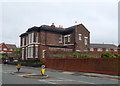
Bus to Croxteth
Arriva Merseyside Wrightbus StreetDeck 4718 (DG71 VGK) on Everton Road.
Image: © David Dixon
Taken: 6 Sep 2022
0.14 miles
9
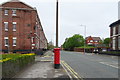
Everton Road
Showing position of Postbox No. L6 15.
See Image] for postbox.
Image: © JThomas
Taken: 28 Apr 2019
0.14 miles
10
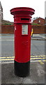
Victorian postbox on Everton Road
Postbox No. L6 15.
See Image] for context.
Image: © JThomas
Taken: 28 Apr 2019
0.14 miles