IMAGES TAKEN NEAR TO
Melda Close, LIVERPOOL, L6 1NN
Introduction
This page details the photographs taken nearby to Melda Close, L6 1NN by members of the Geograph project.
The Geograph project started in 2005 with the aim of publishing, organising and preserving representative images for every square kilometre of Great Britain, Ireland and the Isle of Man.

There are currently over 7.5m images from over14,400 individuals and you can help contribute to the project by visiting https://www.geograph.org.uk
Image Map (Loading...)


Getting Data...Please wait
Leaflet Map data © OpenStreetMap
Images are licensed for reuse under creativecommons.org/licenses/by-sa/2.0
Notes
- Clicking on the map will re-center to the selected point.
- The higher the marker number, the further away the image location is from the centre of the postcode.
Image Listing (59 Images Found)
Images are licensed for reuse under creativecommons.org/licenses/by-sa/2.0
Image
Details
Distance
1
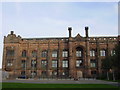
The Liverpool Collegiate School
The Liverpool Collegiate School, Shaw Street, was founded in 1840 under the name Liverpool Collegiate Institution, as a day school for boys. The main purpose of the school was to provide the sons of the middle class with a suitable education incorporating a combination of scientific, commercial and religious instruction. At its opening the college was divided into three schools; Upper, Middle and the Lower Schools. In 1884 the Upper School moved to a site on Lodge Lane whilst the others remained at Shaw Street. Eventually, in 1907 the schools formally split when the Middle and Commercial Schools were sold to the city. The Upper School continued as Liverpool College and became a public school, the Middle and Commercial Schools united under the name Liverpool Collegiate School and continued until its closure in 1985.
The building has now been converted into apartments.
Image: © Sue Adair
Taken: 31 Oct 2005
0.10 miles
2
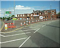
The A580 Brunswick Road, leading to the start of the M62
Image: © Ian S
Taken: 8 May 2011
0.10 miles
3
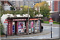
Facade of Gregsons Well public house, Liverpool
Since the photo was taken the rest of the building has been demolished.
Image: © Mike Pennington
Taken: 17 Oct 2015
0.11 miles
4
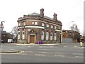
The Old Bank, Everton Road, Liverpool
The building, presumably a former bank branch, now appears to be used as student accommodation.
Image: © Graham Robson
Taken: 13 Mar 2016
0.11 miles
5
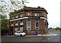
The Old Bank on Everton Road
A former bank now used as student accommodation.
Image: © JThomas
Taken: 28 Apr 2019
0.11 miles
6
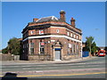
Former bank, corner of Everton Road and Brunswick Road, Liverpool
Thanks to John Robertson for pointing out that this was originally the Midland Bank, Everton Road Branch. My original guess was that "TASS" over the door indicated a connection with the Technical, Administrative and Supervisory Staffs, associated with the Amalgamated Union of Engineering Workers. Now to let, and situated on the busy junction of Brunswick Road, Everton Road, West Derby Road and Low Hill, northeast of the city centre.
Image: © Derek Harper
Taken: 17 Jul 2006
0.11 miles
8
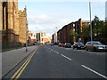
Shaw Street, Everton
There is a cut bench mark on the corner of the building to the right of the photograph and a closer view can be seen here: Image
Image: © Mark Anderson
Taken: 28 Oct 2024
0.13 miles
9
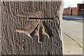
Cut Bench Mark, Liverpool Collegiate School
The mark faces onto Shaw Street at the junction with College Street South. Bench Mark Database: https://www.bench-marks.org.uk/bm88265
Image: © Mark Anderson
Taken: 28 Oct 2024
0.13 miles
10
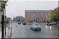
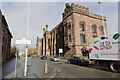
Everton Road approaching Brunswick Road
Image: © Mark Anderson
Taken: 29 Oct 2024
0.14 miles