IMAGES TAKEN NEAR TO
Daisy Street, LIVERPOOL, L5 7RW
Introduction
This page details the photographs taken nearby to Daisy Street, L5 7RW by members of the Geograph project.
The Geograph project started in 2005 with the aim of publishing, organising and preserving representative images for every square kilometre of Great Britain, Ireland and the Isle of Man.

There are currently over 7.5m images from over14,400 individuals and you can help contribute to the project by visiting https://www.geograph.org.uk
Image Map
Images are licensed for reuse under creativecommons.org/licenses/by-sa/2.0
Notes
- Clicking on the map will re-center to the selected point.
- The higher the marker number, the further away the image location is from the centre of the postcode.
Image Listing (31 Images Found)
Images are licensed for reuse under creativecommons.org/licenses/by-sa/2.0
Image
Details
Distance
1
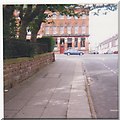
Fountains Road, Stanley Road, Kirkdale, Liverpool
The view is from opposite Newman Street looking towards the public house on Stanley Road; the sandstone wall surrounded the old Stanley hospital. In the autumn of 1940, during an air raid an oil bomb landed against this wall, and took a very long time to reach the ground i.e. the plane must have been at a great height.
Image: © lesbell
Taken: Unknown
0.06 miles
2
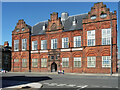
Former institute, Stanley Road, Liverpool
Built as the Gordon Working Lads' Institute in 1886 to the designs of David Walker. Excellent and quite unusual brick detail to the windows (Image]). "A handsome building (which would be more so if it had not lost finials and a cupola), it provided technical and physical education for the sons of working class, and contained classrooms, a gymnasium and a concert hall." Grade II listed.
It now serves as Kirkdale Community Centre.
Image: © Stephen Richards
Taken: 13 Jul 2016
0.10 miles
3
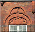
Detail of former institute, Stanley Road, Liverpool
Example of the elaborate brick tracery above the windows of this building Image
Image: © Stephen Richards
Taken: 13 Jul 2016
0.10 miles
4
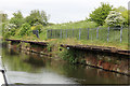
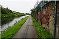
Manure Wharves
These are the remains of manure wharves in Kirkdale by the Leeds and Liverpool Canal. In the 19th century ‘night soil men’ collected Liverpool’s refuse, which included horse manure and human waste. This was removed by horse drawn cart and dumped on canal side manure wharves where it was sorted and loaded into specially adapted boats to be taken out to fertilize the fields of Lancashire.
Image: © Stephen Keenan
Taken: 6 May 2017
0.10 miles
5
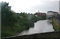
Leeds to Liverpool canal at Kirkdale
Image: © Mike Pennington
Taken: 10 Jul 2010
0.11 miles
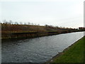
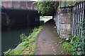
8
Flotsam and Jetsam
General urban decay around the canal at Sandhills, where the railway crosses just north of Sandhills station.
Image: © Roger May
Taken: 6 Feb 2006
0.12 miles
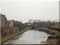
10
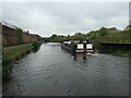
Today's leisure, yesterday's waste disposal, Bootle
The hotel boat Lady Teal passing the former North Corporation Yard wharf on the Leeds & Liverpool canal. This was where the 'night soil' from the non-flushing toilets of Liverpool and the manure from horse-drawn vehicles was transferred into canal boats to enrich the arable fields of West Lancashire.
Image: © Christine Johnstone
Taken: 26 May 2021
0.12 miles