IMAGES TAKEN NEAR TO
Thirlmere Green, LIVERPOOL, L5 6SU
Introduction
This page details the photographs taken nearby to Thirlmere Green, L5 6SU by members of the Geograph project.
The Geograph project started in 2005 with the aim of publishing, organising and preserving representative images for every square kilometre of Great Britain, Ireland and the Isle of Man.

There are currently over 7.5m images from over14,400 individuals and you can help contribute to the project by visiting https://www.geograph.org.uk
Image Map (24 Images)


Getting Data...Please wait
Leaflet Map data © OpenStreetMap
Images are licensed for reuse under creativecommons.org/licenses/by-sa/2.0
Notes
- Clicking on the map will re-center to the selected point.
- The higher the marker number, the further away the image location is from the centre of the postcode.
Image Listing (24 Images Found)
Images are licensed for reuse under creativecommons.org/licenses/by-sa/2.0
Image
Details
Distance
2
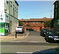
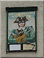
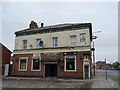
Breck Road
Breck Road is an ancient road leading from West Derby to Liverpool, Breck is an Old English word meaning uncultivated land as this would have been mainly countryside before the building of the shops and houses in the second half of the 19th century. It is unusual in that the property numbers run from West Derby to the city rather than the other way round. It is still a busy shopping area an on the right of the photograph are the Windermere and Breck (closed) public houses.
Image: © Sue Adair
Taken: 1 May 2007
0.08 miles
3
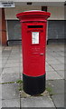
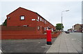
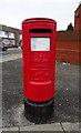
Elizabeth II postbox on Breck Road, Liverpool
Postbox No. L5 434.
See Image] for context.
Image: © JThomas
Taken: 28 Apr 2019
0.08 miles
4
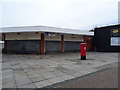
Breck Road Community Library, Liverpool
Showing position of Postbox No. L5 434.
See Image] for postbox.
Image: © JThomas
Taken: 28 Apr 2019
0.09 miles
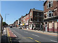
5
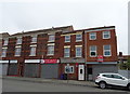
Businesses on Breckfield Road North, Liverpool
Mostly closed on Sunday.
Image: © JThomas
Taken: 28 Apr 2019
0.10 miles
8

14-20 Breckfield Road North, Demolished
Image: © Alex McGregor
Taken: 20 Jun 2011
0.10 miles
9
Breckfield Road North
Showing position of Postbox No. L5 533.
Image: © JThomas
Taken: 28 Apr 2019
0.11 miles
10
Elizabeth II postbox on Breckfield Road North
Postbox No. L5 533.
Image: © JThomas
Taken: 28 Apr 2019
0.11 miles