IMAGES TAKEN NEAR TO
Little Heyes Street, LIVERPOOL, L5 6SQ
Introduction
This page details the photographs taken nearby to Little Heyes Street, L5 6SQ by members of the Geograph project.
The Geograph project started in 2005 with the aim of publishing, organising and preserving representative images for every square kilometre of Great Britain, Ireland and the Isle of Man.

There are currently over 7.5m images from over14,400 individuals and you can help contribute to the project by visiting https://www.geograph.org.uk
Image Map
Images are licensed for reuse under creativecommons.org/licenses/by-sa/2.0
Notes
- Clicking on the map will re-center to the selected point.
- The higher the marker number, the further away the image location is from the centre of the postcode.
Image Listing (32 Images Found)
Images are licensed for reuse under creativecommons.org/licenses/by-sa/2.0
Image
Details
Distance
1
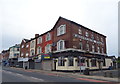
Oakfield Road toward LFC
Looking in the other direction, LFC looms above the old victorian skyline
Image: © russ
Taken: Unknown
0.02 miles
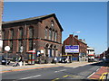
2
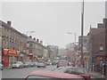
The real Anfield
This is Oakfield Road looking away from LFC. The name Anfield comes from the name Ann's Field. The victorians heavily built on this prominent position which overlooks the city and also the river. Although the present day Anfield is slightly grotty, the area was originally THE place to live.
Image: © russ
Taken: Unknown
0.02 miles
4

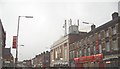
Oakfield Road after the match.
Football crowd head home after Liverpool beat Everton 1-0.
Image: © Colin Pyle
Taken: 6 Feb 2010
0.06 miles
5
Richmond Baptist Chapel, Breck Road
Richmond Baptist Chapel on Breck Road near the junction with Walton Breck Road was opened in 1864.
Image: © Sue Adair
Taken: 1 May 2007
0.12 miles
6
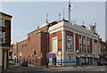
Liverpool Lighthouse, Oakfield Road
The former Gaumont Palace cinema, opened in 1931 and closed in 1960. After a variety of subsequent uses, it finally became derelict, but was revived in 2005 to become a gospel-based centre for the performing arts. A fine example of Art-Deco in a semi-classical style, using faience facings for the main facade.
Image: © Alan Murray-Rust
Taken: 8 Apr 2013
0.13 miles
7
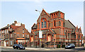
Former Presbyterian Church, Oakfield Road
I could not make out whether the building is still in use, but it is certainly no longer a Presbyterian place of worship. The styling of the terracotta facings to the brindled common brickwork is striking and unusual.
Image: © Alan Murray-Rust
Taken: 8 Apr 2013
0.14 miles
8
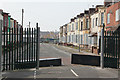
Salisbury Road, Anfield
A sad image of decayed Victorian suburbia, testament to the reduction in Liverpool's population in recent decades. The further end of the street has already been demolished.
Image: © Alan Murray-Rust
Taken: 8 Apr 2013
0.14 miles
9
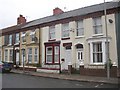
Terrace houses, Anfield, Liverpool
These terrace houses were evidently built with pride, with an ornate eaves cornice of decorated sections moulded to form arches. A pity that there are so many different colour schemes.
Image: © Humphrey Bolton
Taken: 30 Jun 2007
0.16 miles