IMAGES TAKEN NEAR TO
Heyworth Street, LIVERPOOL, L5 4LJ
Introduction
This page details the photographs taken nearby to Heyworth Street, L5 4LJ by members of the Geograph project.
The Geograph project started in 2005 with the aim of publishing, organising and preserving representative images for every square kilometre of Great Britain, Ireland and the Isle of Man.

There are currently over 7.5m images from over14,400 individuals and you can help contribute to the project by visiting https://www.geograph.org.uk
Image Map
Images are licensed for reuse under creativecommons.org/licenses/by-sa/2.0
Notes
- Clicking on the map will re-center to the selected point.
- The higher the marker number, the further away the image location is from the centre of the postcode.
Image Listing (32 Images Found)
Images are licensed for reuse under creativecommons.org/licenses/by-sa/2.0
Image
Details
Distance
1
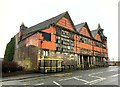
The Mere Bank, Everton
The listed pub dates from 1881 and is described at http://list.english-heritage.org.uk/resultsingle.aspx?uid=1343621&searchtype=mapsearch : "Richly ornamented". In the background is Image
Image: © Derek Harper
Taken: 17 Jul 2006
0.01 miles
2
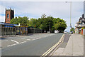
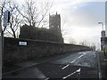
Bus Stop on Heyworth Street
Bus stop outside the Beacon CE Primary School on Heyworth Street. The tower of St George's Church, Everton is prominent in the background.
Image: © David Dixon
Taken: 6 Sep 2022
0.03 miles
3
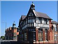
Everton Library, Liverpool
The former Everton Library building, the building which dates from 1896 currently appears to be disused. The building is grade II listed. https://www.historicengland.org.uk/listing/the-list/list-entry/1207466
Image: © Graham Robson
Taken: 13 Mar 2016
0.03 miles
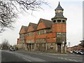
4
Everton library from the south
Thomas Shelmerdine's extraordinary late Victorian triangular building, here seen across Beacon Lane. A description is at http://list.english-heritage.org.uk/resultsingle.aspx?uid=1207466&searchtype=mapsearch .
Image: © Derek Harper
Taken: 17 Jul 2006
0.03 miles
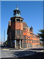
5
Derelict Library on St Domingo Road
The former Everton Library, sadly in a continuing state of decline as at the date of posting. The filthy winter weather on the day doesn't do a lot to help.
Image: © Jonathan Clitheroe
Taken: 6 Feb 2024
0.04 miles
6
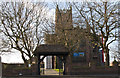
A silhouette of St George's Church, Everton
St George's Church from Grecian Terrace.
Image: © John S Turner
Taken: 21 Jan 2012
0.05 miles
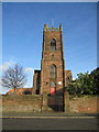
8
St. George's Church, Everton
Early C19 church in commanding position. "The cast iron structure is an important early example, the result of the encouragement of John Cragg, owner of the Mersey Iron Foundry" https://historicengland.org.uk/listing/the-list/list-entry/1075216 . In the foreground is part of Beacon Primary School.
Image: © Derek Harper
Taken: 17 Jul 2006
0.05 miles
9
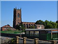
St George's Church, Northumberland Terrace, Everton
St George's church is Grade I listed and is unusual in that it incorporates some cast iron components. In the mid 19th century it was surrounded by large houses with large gardens, but by 1890 that had all changed to row after row of terraced housing. The terraces have now been cleared away to make way for modern housing, North Liverpool Academy, and Everton Park.
Image: © John S Turner
Taken: 21 Jan 2012
0.06 miles
10
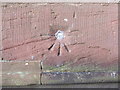
1GL bench mark and bolt on St George's Church, Everton
This 1 GL bench mark and bolt is on the south east face of the church tower - Image
Image: © John S Turner
Taken: 21 Jan 2012
0.06 miles