IMAGES TAKEN NEAR TO
Heyworth Street, LIVERPOOL, L5 4LA
Introduction
This page details the photographs taken nearby to Heyworth Street, L5 4LA by members of the Geograph project.
The Geograph project started in 2005 with the aim of publishing, organising and preserving representative images for every square kilometre of Great Britain, Ireland and the Isle of Man.

There are currently over 7.5m images from over14,400 individuals and you can help contribute to the project by visiting https://www.geograph.org.uk
Image Map
Images are licensed for reuse under creativecommons.org/licenses/by-sa/2.0
Notes
- Clicking on the map will re-center to the selected point.
- The higher the marker number, the further away the image location is from the centre of the postcode.
Image Listing (39 Images Found)
Images are licensed for reuse under creativecommons.org/licenses/by-sa/2.0
Image
Details
Distance
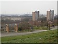
1
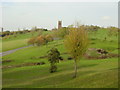
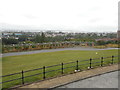
Everton Park
Everton Village was, in the 18th century, a pastoral village, set upon Everton Brow, some distance from the increasingly prosperous Port of Liverpool. With unsurpassable views across the River Mersey to the Welsh hills and over the city to the as yet unspoilt rolling countryside, it must have been a desirable place to live. With the onset of the Great Irish Famine and the Industrial Revolution, immigrants from Ireland and Wales, as well as the impoverished victims of enclosures in rural England, poured into the city to attempt to make a living in the burgeoning factories serving the manufacturing industries.
The demands of such a population upon the area changed the landscape dramatically. To accommodate this influx, densely packed rows of back to back houses were built on the hills surrounding the village. The village was quickly subsumed into the industrial conglomerate. With the arrival of the 60s came the demolition of terraced streets, which had become such a landmark, visible as they were from the river, to be replaced by high rise blocks of flats and the green and pleasant hills of Everton were just a distant curiosity to be wondered at in antiquarian prints and books.
It took merely a decade or two to realise the disaster that was 'sixties built' high rise dwelling. The 1980s brought a return to a more sociable style of housing development and with this the creation of the open green space that became Everton Park.
Image: © Sue Adair
Taken: 31 Oct 2005
0.07 miles
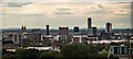
3
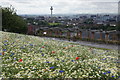
Wild flower meadow on Everton Brow
Looking towards Liverpool city centre and the Radio City Tower, as it is currently named.
Image: © Mike Pennington
Taken: 7 Jul 2015
0.08 miles
4
Everton Park, Liverpool
Part of the panoramic view across and out of Everton Park.
Image: © Graham Robson
Taken: 13 Mar 2016
0.10 miles
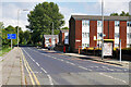
6
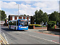
Bus on Breck Road, Everton
Stagecoach Merseyside 24168 (PO59 MXB) ADL Enviro 300 single decker bus on Breck Road in the Everton District of Liverpool.
Image: © David Dixon
Taken: 6 Sep 2022
0.10 miles
7
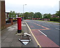
Breck Road, Liverpool
Showing position of Postbox No. L6 3.
See Image] for postbox.
Image: © JThomas
Taken: 28 Apr 2019
0.10 miles
8
Everton Park - View across the Terraces
Image: © Alan Heardman
Taken: 29 Jul 2014
0.10 miles
9
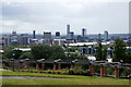
Liverpool skyline from Everton Brow
The Liver Building, on the left, now dwarfed by the skyscrapers built in recent years.
Image: © Mike Pennington
Taken: 7 Jul 2015
0.11 miles
10
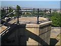
Platform, Everton Park
At the north end of the terrace shown in Image The park gives a fine view over the city.
Image: © Derek Harper
Taken: 17 Jul 2006
0.11 miles