IMAGES TAKEN NEAR TO
Sheriff Close, LIVERPOOL, L5 3SN
Introduction
This page details the photographs taken nearby to Sheriff Close, L5 3SN by members of the Geograph project.
The Geograph project started in 2005 with the aim of publishing, organising and preserving representative images for every square kilometre of Great Britain, Ireland and the Isle of Man.

There are currently over 7.5m images from over14,400 individuals and you can help contribute to the project by visiting https://www.geograph.org.uk
Image Map (Loading...)


Getting Data...Please wait
Leaflet Map data © OpenStreetMap
Images are licensed for reuse under creativecommons.org/licenses/by-sa/2.0
Notes
- Clicking on the map will re-center to the selected point.
- The higher the marker number, the further away the image location is from the centre of the postcode.
Image Listing (21 Images Found)
Images are licensed for reuse under creativecommons.org/licenses/by-sa/2.0
Image
Details
Distance
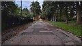
1
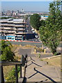
Prince Edwin Street from Everton Park
Rather different from http://web.archive.org/web/20071017233109/http://www.mersey-gateway.org/server.php?show=conMediaFile.14837 which shows Richard Brown's photo of a court on Prince Edwin Street in 1913. Below on the left, flats are being built at City View. The building behind the trees on the right is Campion Catholic High School. Behind, the northern end of Liverpool city centre.
Image: © Derek Harper
Taken: 17 Jul 2006
0.02 miles
2
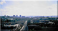
Prince Edwin Street
A view from Everton Park. A lot of building has taken place in the city centre since this was taken.
Image: © Bill Boaden
Taken: 1 Apr 1998
0.06 miles
3
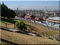
Netherfield Road South, Liverpool
From Image; the steps and railings can be seen in Image The flats at City View are being built on the right. In the distance are the Anglican Cathedral and the Radio City Tower.
Image: © Derek Harper
Taken: 17 Jul 2006
0.10 miles
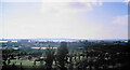
4
Netherfield Road South
Looking down from Everton Park. The two cathedrals are in view, but the three tower blocks no longer exist.
Image: © Bill Boaden
Taken: 1 Apr 1998
0.12 miles
5
Path to Roscommon Street
Path from Great Homer Street to Roscommon Street
Image: © Shaun Ferguson
Taken: 21 Oct 2021
0.12 miles
6
Everton Park
Some of the park gives a raised view over Liverpool. St Anthony's Catholic Church is prominent towards the right. New Brighton is in the background. Another Catholic church can be seen in New Brighton, that of Sts Peter & Paul & St Philomena.
Image: © Bill Boaden
Taken: 1 Apr 1998
0.12 miles
7
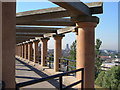
Terrace, Everton Park
Between the columns can be seen the two Liverpool cathedrals and St Francis Xavier's spire.
Image: © Derek Harper
Taken: 17 Jul 2006
0.15 miles
8
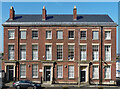
115-119 Shaw Street, Liverpool
Three handsome three-storey, three-bay houses, built c1826. Each has an Ionic porch. They were originally part of a longer terrace, the rest of which was shamefully demolished in the early 2000s. Grade II listed.
The middle house, and possibly the others, are occupied by Riverside, a charity helping homeless people.
Image: © Stephen Richards
Taken: 15 Aug 2016
0.15 miles
9
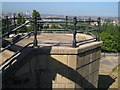
Platform, Everton Park
At the north end of the terrace shown in Image The park gives a fine view over the city.
Image: © Derek Harper
Taken: 17 Jul 2006
0.16 miles
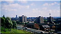
10
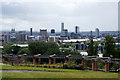
Liverpool skyline from Everton Brow
The Liver Building, on the left, now dwarfed by the skyscrapers built in recent years.
Image: © Mike Pennington
Taken: 7 Jul 2015
0.16 miles