IMAGES TAKEN NEAR TO
Oakfield Road, LIVERPOOL, L5 1AE
Introduction
This page details the photographs taken nearby to Oakfield Road, L5 1AE by members of the Geograph project.
The Geograph project started in 2005 with the aim of publishing, organising and preserving representative images for every square kilometre of Great Britain, Ireland and the Isle of Man.

There are currently over 7.5m images from over14,400 individuals and you can help contribute to the project by visiting https://www.geograph.org.uk
Image Map
Images are licensed for reuse under creativecommons.org/licenses/by-sa/2.0
Notes
- Clicking on the map will re-center to the selected point.
- The higher the marker number, the further away the image location is from the centre of the postcode.
Image Listing (114 Images Found)
Images are licensed for reuse under creativecommons.org/licenses/by-sa/2.0
Image
Details
Distance
1
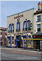
The Sandon, Oakfield Road
This pub can lay claim to being the birthplace of both Everton and Liverpool football clubs, although it is now firmly associated with the latter. The building is a fine example of the most flamboyant style of Art Deco, with the facade created in ornate and colourful faience.
Image: © Alan Murray-Rust
Taken: 8 Apr 2013
0.01 miles
2
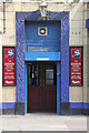
Main door, The Sandon
The door surround is a riot of ornamentation in vivid blue ceramics; see also http://www.geograph.org.uk/photo/3410292
Image: © Alan Murray-Rust
Taken: 8 Apr 2013
0.02 miles
3
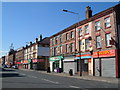
Oakfield Road, Anfield
A view from a little further west than Image along this street of shops not far from the Anfield stadium.
Image: © Derek Harper
Taken: 17 Jul 2006
0.04 miles
4
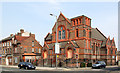
Former Presbyterian Church, Oakfield Road
I could not make out whether the building is still in use, but it is certainly no longer a Presbyterian place of worship. The styling of the terracotta facings to the brindled common brickwork is striking and unusual.
Image: © Alan Murray-Rust
Taken: 8 Apr 2013
0.04 miles
5
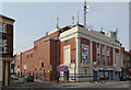
Liverpool Lighthouse, Oakfield Road
The former Gaumont Palace cinema, opened in 1931 and closed in 1960. After a variety of subsequent uses, it finally became derelict, but was revived in 2005 to become a gospel-based centre for the performing arts. A fine example of Art-Deco in a semi-classical style, using faience facings for the main facade.
Image: © Alan Murray-Rust
Taken: 8 Apr 2013
0.04 miles
6
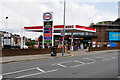
Esso Rontec Anfield
The Esso filling station on Oakfield Road.
Image: © David Dixon
Taken: 6 Sep 2022
0.04 miles
7
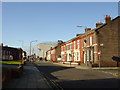
Salisbury Road, Anfield
A sad image of decayed Victorian suburbia, testament to the reduction in Liverpool's population in recent decades. The further end of the street has already been demolished.
Image: © Alan Murray-Rust
Taken: 8 Apr 2013
0.05 miles
8
Walton Breck Road
Terraced housing on Walton Breck Road with the stands of Liverpool FC in the background
Image: © Sue Adair
Taken: 15 Nov 2005
0.06 miles
9
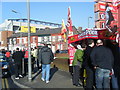
Oakfield Road on match day.
Anfield Stadium looms above the terraced houses and souvenirs are sold, prior to the Everton 'derby' match.
Image: © Colin Pyle
Taken: 6 Feb 2010
0.07 miles
10
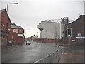
Walton Breck Road, Skerries Road Corner
On a rainy December day in 2004 Walton Breck Road stood in a sodden state! If you're a blue then this place stinks, if you're a red, then this place is heaven. I'll let you make your mind up!
Image: © russ
Taken: Unknown
0.09 miles