IMAGES TAKEN NEAR TO
Maslin Drive, LIVERPOOL, L5 1AD
Introduction
This page details the photographs taken nearby to Maslin Drive, L5 1AD by members of the Geograph project.
The Geograph project started in 2005 with the aim of publishing, organising and preserving representative images for every square kilometre of Great Britain, Ireland and the Isle of Man.

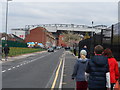
There are currently over 7.5m images from over14,400 individuals and you can help contribute to the project by visiting https://www.geograph.org.uk
Image Map (Loading...)


Getting Data...Please wait
Leaflet Map data © OpenStreetMap
Images are licensed for reuse under creativecommons.org/licenses/by-sa/2.0
Notes
- Clicking on the map will re-center to the selected point.
- The higher the marker number, the further away the image location is from the centre of the postcode.
Image Listing (120 Images Found)
Images are licensed for reuse under creativecommons.org/licenses/by-sa/2.0
Image
Details
Distance
1
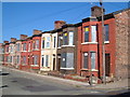
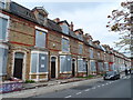
Empty houses in Herschell Street, Anfield
From Glaisher Street. The last family seemed to be in the process of moving out of the terrace opposite.
Image: © Derek Harper
Taken: 17 Jul 2006
0.04 miles
2
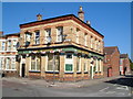
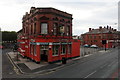
The Salisbury, Anfield
Victorian pub on the corner of Davy Street and Granton Road.
Image: © Derek Harper
Taken: 17 Jul 2006
0.04 miles
3
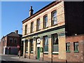
The Salisbury, Anfield
A view of Image from Davy Street.
Image: © Derek Harper
Taken: 17 Jul 2006
0.04 miles
4
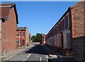
Glaisher Street, Anfield
Most of these houses have since been demolished. The first junction on the left is with Herschell Street - see Image The furthest visible end terraces, at the corners of Donaldson Street, were still standing some years later. At the far end is a T junction with Hartnup Street.
Image: © Derek Harper
Taken: 17 Jul 2006
0.05 miles
5
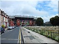
The (rapidly disappearing) streets of Anfield
This is Venmore street and half of it has been demolished. The remaining houses are all boarded-up and ready for demolition. The Kop end of Anfield stadium is visible in the distance.
Image: © Bikeboy
Taken: 19 May 2013
0.08 miles
6
Venmore Street, Liverpool
Quite a derelict street, looks like it may be ready for demolition, but some view to Anfield Stadium.
Image: © Stephen Sweeney
Taken: 22 Jun 2011
0.09 miles
7
Venmore Street, Anfield, ready for demolition
See http://www.geograph.org.uk/photo/2473957 for a 2011 view of this street. Some of the houses were still occupied. Now they are all empty and ready for demolition. The cars parked outside are not those of residents but visitors to Anfield (match day).
Image: © Bikeboy
Taken: 19 May 2013
0.09 miles
8
The Park, Walton Breck Road, Liverpool
Directly opposite Anfield, the home of Liverpool FC.
Image: © Mike Pennington
Taken: 17 Oct 2015
0.11 miles
9
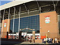
The Kop, Liverpool's Anfield stadium
The famous Kop entrance at Liverpool's Anfield stadium
Image: © Sue Adair
Taken: 15 Nov 2005
0.11 miles
10
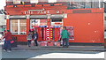
Scarves for sale outside the Park, Anfield
Image: © Mike Pennington
Taken: 25 Aug 2018
0.12 miles