IMAGES TAKEN NEAR TO
Wyre Road, LIVERPOOL, L5 0QX
Introduction
This page details the photographs taken nearby to Wyre Road, L5 0QX by members of the Geograph project.
The Geograph project started in 2005 with the aim of publishing, organising and preserving representative images for every square kilometre of Great Britain, Ireland and the Isle of Man.

There are currently over 7.5m images from over14,400 individuals and you can help contribute to the project by visiting https://www.geograph.org.uk
Image Map
Images are licensed for reuse under creativecommons.org/licenses/by-sa/2.0
Notes
- Clicking on the map will re-center to the selected point.
- The higher the marker number, the further away the image location is from the centre of the postcode.
Image Listing (45 Images Found)
Images are licensed for reuse under creativecommons.org/licenses/by-sa/2.0
Image
Details
Distance
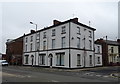
5
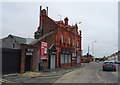
The Glenbuck Hotel, Anfield
On Walton Breck Road.
Image: © JThomas
Taken: 28 Apr 2019
0.09 miles
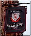
6

The Glenbuck Hotel, Anfield
On Walton Breck Road.
Image: © JThomas
Taken: 28 Apr 2019
0.09 miles
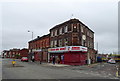
9
Road junction, Anfield, Liverpool
A wide road junction in the Anfield area of Liverpool. Across the junction the shops on the street corners are boarded up and closed.
Image: © Graham Robson
Taken: 13 Mar 2016
0.10 miles
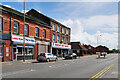
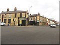
10
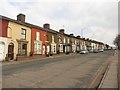
Walton Breck Road, Liverpool
Looking along Walton Breck Road, a residential street of terraced houses in the Anfield area of Liverpool.
Image: © Graham Robson
Taken: 13 Mar 2016
0.12 miles