IMAGES TAKEN NEAR TO
Abingdon Road, LIVERPOOL, L4 9SL
Introduction
This page details the photographs taken nearby to Abingdon Road, L4 9SL by members of the Geograph project.
The Geograph project started in 2005 with the aim of publishing, organising and preserving representative images for every square kilometre of Great Britain, Ireland and the Isle of Man.

There are currently over 7.5m images from over14,400 individuals and you can help contribute to the project by visiting https://www.geograph.org.uk
Image Map
Images are licensed for reuse under creativecommons.org/licenses/by-sa/2.0
Notes
- Clicking on the map will re-center to the selected point.
- The higher the marker number, the further away the image location is from the centre of the postcode.
Image Listing (6 Images Found)
Images are licensed for reuse under creativecommons.org/licenses/by-sa/2.0
Image
Details
Distance
1
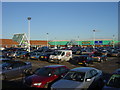
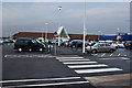
Asda car park, Utting Avenue
Asda complex, Utting Avenue, photo taken from Abingdon Road. The car park is full due to being Saturday afternoon and Liverpool are playing Tottenham at home.
Image: © Sue Adair
Taken: 14 Jan 2006
0.05 miles
4
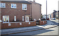
Newer extension to Victorian end of Woodland road
View of the Victorian end of Woodland road with the start of the extension built after WW1 by Liverpool corporation. No 24 narrowly missed destruction when an incendiary bomb hit the pavement at the gate in the May blitz just missing the house. The tenant, Frank Lewis was able to extinguish the blaze with a sandbag that the corporation had thoughtfully provided on the doorsteps of every house.
Image: © stan lewis
Taken: 11 Mar 2010
0.23 miles
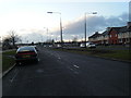
5
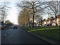
Queens Drive nearing Atheldene Road
A car can be seen on the right about to exit Atheldene Road.
Image: © Peter Whatley
Taken: 17 Jan 2012
0.24 miles
6
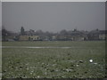
Richard Kelly Field
The Field is in between Richard Kelly Drive and Abingdon Road. To the right is Caspian Road. In the distance is the disused Railway Bridge in Philbeach Road. (Now known as the Cycle Path) underneath the bridge is Norris Green. For many years both Norris Green and Walton locals have used this field for leisure, football being the most popular.
Image: © andy miller
Taken: Unknown
0.25 miles