IMAGES TAKEN NEAR TO
L48 7EF
Introduction
This page details the photographs taken nearby to L48 7EF by members of the Geograph project.
The Geograph project started in 2005 with the aim of publishing, organising and preserving representative images for every square kilometre of Great Britain, Ireland and the Isle of Man.

There are currently over 7.5m images from over14,400 individuals and you can help contribute to the project by visiting https://www.geograph.org.uk
Image Map
Images are licensed for reuse under creativecommons.org/licenses/by-sa/2.0
Notes
- Clicking on the map will re-center to the selected point.
- The higher the marker number, the further away the image location is from the centre of the postcode.
Image Listing (8 Images Found)
Images are licensed for reuse under creativecommons.org/licenses/by-sa/2.0
Image
Details
Distance
1
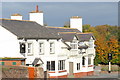
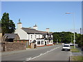
The Collingwood Bar and Restaurant
The Collingwood West Kirby
Image: © Steve Atkinson
Taken: 31 Oct 2007
0.09 miles
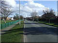
2
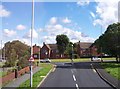
Greenbank Road joins Blackhorse Hill at West Kirby
Image: © Raymond Knapman
Taken: 30 Aug 2012
0.10 miles
3
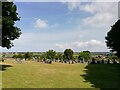
Grange Cemetery
Grange Cemetery between Lang Lane and Blackhorse Hill was opened after the First World War, the site was purchased in 1913.
Image: © Sue Adair
Taken: 3 Aug 2021
0.11 miles
5
The Black Horse Inn, West Kirby
The Black Horse Inn, on Black Horse Hill, between West Kirby and Newton.
Image: © Sue Adair
Taken: 7 Aug 2006
0.14 miles
7
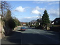
Black Horse Hill (B5139)
Towards Birkenhead.
Image: © JThomas
Taken: 1 Mar 2014
0.18 miles