IMAGES TAKEN NEAR TO
Elm Road, LIVERPOOL, L4 5UT
Introduction
This page details the photographs taken nearby to Elm Road, L4 5UT by members of the Geograph project.
The Geograph project started in 2005 with the aim of publishing, organising and preserving representative images for every square kilometre of Great Britain, Ireland and the Isle of Man.

There are currently over 7.5m images from over14,400 individuals and you can help contribute to the project by visiting https://www.geograph.org.uk
Image Map (Loading...)


Getting Data...Please wait
Leaflet Map data © OpenStreetMap
Images are licensed for reuse under creativecommons.org/licenses/by-sa/2.0
Notes
- Clicking on the map will re-center to the selected point.
- The higher the marker number, the further away the image location is from the centre of the postcode.
Image Listing (13 Images Found)
Images are licensed for reuse under creativecommons.org/licenses/by-sa/2.0
Image
Details
Distance
2
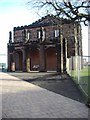
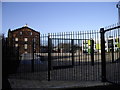
Walton Hall Foot Clinic
Chiropodist and Podiatrists clinic on Walton Hall Avenue
Image: © Eirian Evans
Taken: 12 May 2016
0.14 miles
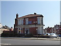
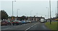
3
The Famous Blue Star Chippy, Queens Drive, Walton
Image: © Mike Pennington
Taken: 27 Jul 2007
0.14 miles
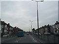
6
Eastern end of Walton Hall Avenue (A580)
The "docks" arm of the East Lancashire Road from its junction with Queens Drive.
Image: © Peter Whatley
Taken: 17 Jan 2012
0.19 miles
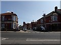
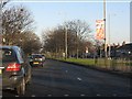
9
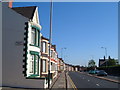
Walton Lane, Liverpool
Looking north along the A580. Opposite the houses is Anfield Cemetery (lodge on right)
Image: © Derek Harper
Taken: 17 Jul 2006
0.20 miles