IMAGES TAKEN NEAR TO
Shepston Avenue, LIVERPOOL, L4 5SU
Introduction
This page details the photographs taken nearby to Shepston Avenue, L4 5SU by members of the Geograph project.
The Geograph project started in 2005 with the aim of publishing, organising and preserving representative images for every square kilometre of Great Britain, Ireland and the Isle of Man.

There are currently over 7.5m images from over14,400 individuals and you can help contribute to the project by visiting https://www.geograph.org.uk
Image Map
Images are licensed for reuse under creativecommons.org/licenses/by-sa/2.0
Notes
- Clicking on the map will re-center to the selected point.
- The higher the marker number, the further away the image location is from the centre of the postcode.
Image Listing (32 Images Found)
Images are licensed for reuse under creativecommons.org/licenses/by-sa/2.0
Image
Details
Distance
1
Walton Lane, Liverpool
Looking north along the A580. Opposite the houses is Anfield Cemetery (lodge on right)
Image: © Derek Harper
Taken: 17 Jul 2006
0.07 miles
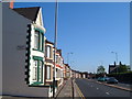
2
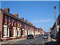
Housing, Kirkdale
Terraced housing in Kirkdale, Liverpool.
Image: © William Starkey
Taken: 15 Mar 2015
0.09 miles
3
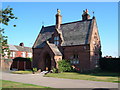
Lodge, Anfield Cemetery
This lodge, described at https://historicengland.org.uk/listing/the-list/list-entry/1062569 , is on the northwestern side of the cemetery beside Walton Lane. https://historicengland.org.uk/listing/the-list/list-entry/1000993 .
Image: © Derek Harper
Taken: 17 Jul 2006
0.09 miles
4
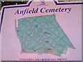
Plan of Anfield Cemetery
Close to the lodge shown in Image The C19 layout is described at https://historicengland.org.uk/listing/the-list/list-entry/1000993 .
Image: © Derek Harper
Taken: 17 Jul 2006
0.09 miles
5
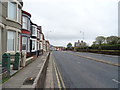
Milman Road, Walton
One of several streets running off at right angles from Walton Lane opposite Anfield Cemetery.
Image: © Derek Harper
Taken: 17 Jul 2006
0.10 miles
6
Walton Lane
Looking north east on the A580.
Image: © JThomas
Taken: 28 Apr 2019
0.10 miles
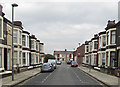
7

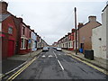
Housing, Kirkdale
Terraced housing in Kirkdale, with Goodison Park just visible in the distance.
Image: © William Starkey
Taken: 15 Mar 2015
0.11 miles
8
Bardsay Road
Looking north west from Walton Lane.
Image: © JThomas
Taken: 28 Apr 2019
0.12 miles
9
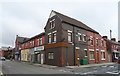
Shops and houses on City Road
Junction with Bodmin Road.
Image: © JThomas
Taken: 28 Apr 2019
0.12 miles
