IMAGES TAKEN NEAR TO
Walton Road, LIVERPOOL, L4 4BB
Introduction
This page details the photographs taken nearby to Walton Road, L4 4BB by members of the Geograph project.
The Geograph project started in 2005 with the aim of publishing, organising and preserving representative images for every square kilometre of Great Britain, Ireland and the Isle of Man.

There are currently over 7.5m images from over14,400 individuals and you can help contribute to the project by visiting https://www.geograph.org.uk
Image Map
Images are licensed for reuse under creativecommons.org/licenses/by-sa/2.0
Notes
- Clicking on the map will re-center to the selected point.
- The higher the marker number, the further away the image location is from the centre of the postcode.
Image Listing (43 Images Found)
Images are licensed for reuse under creativecommons.org/licenses/by-sa/2.0
Image
Details
Distance
1
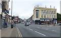
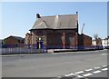
The Thomas Frost in Liverpool
A Wetherspoon pub on Walton Road.
Image: © Mat Fascione
Taken: 26 Jun 2016
0.04 miles
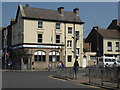
3
The Thomas Frost
Wetherspoons pub in Kirkdale, Liverpool.
Image: © Stephen Sweeney
Taken: 22 Jun 2011
0.06 miles
6
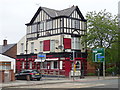
The Abbey Public House, Anfield
On Walton Lane.
Image: © JThomas
Taken: 28 Apr 2019
0.16 miles
7
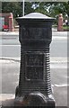
Old Milepost and Boundary Marker by the A580, Walton Lane, Stanley Park, Anfield
Metal post with attached metal plate by the A580, in parish of LIVERPOOL (LIVERPOOL District), Walton Lane, opposite Stanley Park, at junction with Tetlow Street in front of Abbey PH on pavement, on West side of road. Erected by the Local Highways Board in the 19th century.
Inscription reads:-
: TOWN HALL / 2. MILES / 826. YARDS / HEIGHT ABOVE OLD / DOCK SILL / 145.5. FEET {decoration} : : BOROUGH / OF / LIVERPOOL : : 1865 / ERECTED / BY THE / HEALTH / COMMITTEE :
Grade II listed.
List Entry Number: 1062571 https://historicengland.org.uk/listing/the-list/list-entry/1062571
Milestone Society National ID: LA_LV02 and LA_LVWA01pb
Image: © M Faherty
Taken: 24 Aug 2008
0.17 miles
8
Salop Chapel
Liverpool Free Presbyterian Church, known locally as ‘Salop Chapel’, is situated in Walton, adjacent to Everton FC’s ground. The witness began in 1981 when the Protestant Reformers Memorial Church, Liverpool, applied to join the Presbytery of the Free Presbyterian Church of Ulster. It was duly accepted into the Presbytery in March 1981, becoming the first Free Presbyterian Church on the mainland.
Image: © Eirian Evans
Taken: 12 May 2016
0.18 miles
9
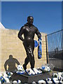
Dixie Dean's Statue
The specially commissioned 10ft bronze Statue of Dixie Dean was unveiled on the 4th May 2001 at the Park End of Goodison Park where Dixie scored his 60th League goal on 5th May 1928, a record which will never be broken. William Ralph 'Dixie' Dean 1907-1980 scored 377 goals in 431 games.
Image: © Sue Adair
Taken: 14 Mar 2007
0.18 miles