IMAGES TAKEN NEAR TO
Carisbrooke Road, LIVERPOOL, L4 3QX
Introduction
This page details the photographs taken nearby to Carisbrooke Road, L4 3QX by members of the Geograph project.
The Geograph project started in 2005 with the aim of publishing, organising and preserving representative images for every square kilometre of Great Britain, Ireland and the Isle of Man.

There are currently over 7.5m images from over14,400 individuals and you can help contribute to the project by visiting https://www.geograph.org.uk
Image Map
Images are licensed for reuse under creativecommons.org/licenses/by-sa/2.0
Notes
- Clicking on the map will re-center to the selected point.
- The higher the marker number, the further away the image location is from the centre of the postcode.
Image Listing (28 Images Found)
Images are licensed for reuse under creativecommons.org/licenses/by-sa/2.0
Image
Details
Distance
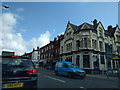
3
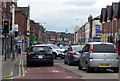
Traffic on the A59 in Walton, Liverpool
Image: © Mat Fascione
Taken: 26 Jun 2016
0.12 miles
5
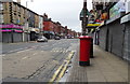
County Road (A59)
Showing position of Postbox No. L4 270.
See Image] for postbox.
Image: © JThomas
Taken: 28 Apr 2019
0.13 miles
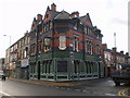
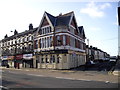
6
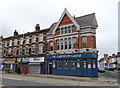
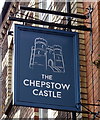
The Chepstow Castle public house
Showing position of Postbox No. L4 270.
See Image] for postbox.
Image: © JThomas
Taken: 28 Apr 2019
0.13 miles
7
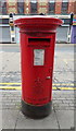
Elizabeth II postbox on County Road
Image: © JThomas
Taken: 28 Apr 2019
0.13 miles
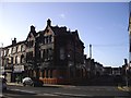
9
The Brick pub, on the corner of Eton Street
Image: © Rob Purvis
Taken: 8 Aug 2016
0.14 miles
10
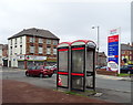
Pair of KX100 PLUS telephone boxes on Lowell Street
Now the entrance to a supermarket.
Image: © JThomas
Taken: 28 Apr 2019
0.16 miles