IMAGES TAKEN NEAR TO
Barlow Lane, LIVERPOOL, L4 3QR
Introduction
This page details the photographs taken nearby to Barlow Lane, L4 3QR by members of the Geograph project.
The Geograph project started in 2005 with the aim of publishing, organising and preserving representative images for every square kilometre of Great Britain, Ireland and the Isle of Man.

There are currently over 7.5m images from over14,400 individuals and you can help contribute to the project by visiting https://www.geograph.org.uk
Image Map
Images are licensed for reuse under creativecommons.org/licenses/by-sa/2.0
Notes
- Clicking on the map will re-center to the selected point.
- The higher the marker number, the further away the image location is from the centre of the postcode.
Image Listing (9 Images Found)
Images are licensed for reuse under creativecommons.org/licenses/by-sa/2.0
Image
Details
Distance
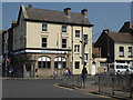
1
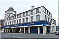
The Thomas Frost in Liverpool
A Wetherspoon pub on Walton Road.
Image: © Mat Fascione
Taken: 26 Jun 2016
0.09 miles
2
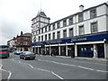
The Thomas Frost
Wetherspoons pub in Kirkdale, Liverpool.
Image: © Stephen Sweeney
Taken: 22 Jun 2011
0.10 miles
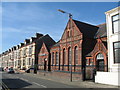
4
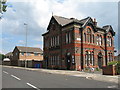
Medlock Hotel Rumney Road
The Medlock Hotel on Rumney Road is a late 19th century public house built adjacent to Kirkdale Gaol which was built in 1818 and demolished in 1897. This land became Kirkdale Recreation Ground but hid a gruesome past.
info:- http://www.old-merseytimes.co.uk/kirkdalegaol.html
Image: © Sue Adair
Taken: 13 Jun 2020
0.15 miles
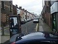
7
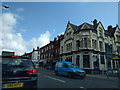
The Brick pub, on the corner of Eton Street
Image: © Rob Purvis
Taken: 8 Aug 2016
0.22 miles
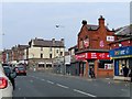
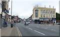
8
Oxton Street
Looking up from County Road with Goodison Park at the far end of the street.
Image: © Colin Pyle
Taken: 15 Oct 2009
0.24 miles