IMAGES TAKEN NEAR TO
Garnett Avenue, LIVERPOOL, L4 1TS
Introduction
This page details the photographs taken nearby to Garnett Avenue, L4 1TS by members of the Geograph project.
The Geograph project started in 2005 with the aim of publishing, organising and preserving representative images for every square kilometre of Great Britain, Ireland and the Isle of Man.

There are currently over 7.5m images from over14,400 individuals and you can help contribute to the project by visiting https://www.geograph.org.uk
Image Map
Images are licensed for reuse under creativecommons.org/licenses/by-sa/2.0
Notes
- Clicking on the map will re-center to the selected point.
- The higher the marker number, the further away the image location is from the centre of the postcode.
Image Listing (7 Images Found)
Images are licensed for reuse under creativecommons.org/licenses/by-sa/2.0
Image
Details
Distance
2
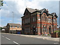
Medlock Hotel Rumney Road
The Medlock Hotel on Rumney Road is a late 19th century public house built adjacent to Kirkdale Gaol which was built in 1818 and demolished in 1897. This land became Kirkdale Recreation Ground but hid a gruesome past.
info:- http://www.old-merseytimes.co.uk/kirkdalegaol.html
Image: © Sue Adair
Taken: 13 Jun 2020
0.12 miles
3
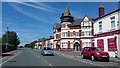
Once The Melrose Public House
Now split into flats.
Image: © Anthony Parkes
Taken: 8 Jul 2017
0.18 miles
4
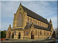
St John the Evangelist, Fountain Road, Kirkdale
In 1870 there was no Catholic church in Kirkdale. In 1871 a building which had been a Congregational Chapel was opened for Mass on February 12th by Father Moses Doon (Dawn?) who also began the school in the basement of this little chapel. The Sessions Road school was opened in 1878 and the church itself was not opened until 20th November 1885. The interior is quite impressive with some beautiful stained glass windows and magnificent altars.
Image: © Sue Adair
Taken: 4 Feb 2008
0.20 miles
5
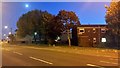
Westminster Road, Kirkdale, at night
Image: © Mike Pennington
Taken: 22 Oct 2015
0.24 miles
6
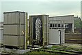
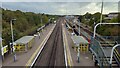
Washing Plant, Kirkdale TMD
Situated in the railway yard, next to the traction maintenance depot. In the background is the carriage shed. Viewed from a train, heading from Kirkdale to Sandhills.
Image: © El Pollock
Taken: 13 Jun 2012
0.25 miles