IMAGES TAKEN NEAR TO
Great Heath Road, LIVERPOOL, L4 1AB
Introduction
This page details the photographs taken nearby to Great Heath Road, L4 1AB by members of the Geograph project.
The Geograph project started in 2005 with the aim of publishing, organising and preserving representative images for every square kilometre of Great Britain, Ireland and the Isle of Man.

There are currently over 7.5m images from over14,400 individuals and you can help contribute to the project by visiting https://www.geograph.org.uk
Image Map (Loading...)


Getting Data...Please wait
Leaflet Map data © OpenStreetMap
Images are licensed for reuse under creativecommons.org/licenses/by-sa/2.0
Notes
- Clicking on the map will re-center to the selected point.
- The higher the marker number, the further away the image location is from the centre of the postcode.
Image Listing (8 Images Found)
Images are licensed for reuse under creativecommons.org/licenses/by-sa/2.0
Image
Details
Distance
1
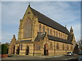
St John the Evangelist, Fountain Road, Kirkdale
In 1870 there was no Catholic church in Kirkdale. In 1871 a building which had been a Congregational Chapel was opened for Mass on February 12th by Father Moses Doon (Dawn?) who also began the school in the basement of this little chapel. The Sessions Road school was opened in 1878 and the church itself was not opened until 20th November 1885. The interior is quite impressive with some beautiful stained glass windows and magnificent altars.
Image: © Sue Adair
Taken: 4 Feb 2008
0.13 miles
2
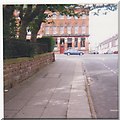
Fountains Road, Stanley Road, Kirkdale, Liverpool
The view is from opposite Newman Street looking towards the public house on Stanley Road; the sandstone wall surrounded the old Stanley hospital. In the autumn of 1940, during an air raid an oil bomb landed against this wall, and took a very long time to reach the ground i.e. the plane must have been at a great height.
Image: © lesbell
Taken: Unknown
0.16 miles
3
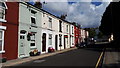
Kearsley Street, Kirkdale, Liverpool
Image: © Mike Pennington
Taken: 25 Aug 2018
0.17 miles
4
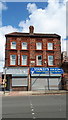
Stanley's Fish & Chips, Stanley Road, Kirkdale, Liverpool
Image: © Mike Pennington
Taken: 25 Aug 2018
0.17 miles
5
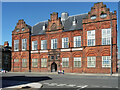
Former institute, Stanley Road, Liverpool
Built as the Gordon Working Lads' Institute in 1886 to the designs of David Walker. Excellent and quite unusual brick detail to the windows (Image]). "A handsome building (which would be more so if it had not lost finials and a cupola), it provided technical and physical education for the sons of working class, and contained classrooms, a gymnasium and a concert hall." Grade II listed.
It now serves as Kirkdale Community Centre.
Image: © Stephen Richards
Taken: 13 Jul 2016
0.21 miles
6
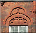
Detail of former institute, Stanley Road, Liverpool
Example of the elaborate brick tracery above the windows of this building Image
Image: © Stephen Richards
Taken: 13 Jul 2016
0.21 miles
7
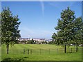
Playing fields at Sandhills from the A567
Image: © Raymond Knapman
Taken: 8 Aug 2012
0.23 miles
8

Reupholstery business on Northumberland Road North
Standing all alone at the junction of Northumberland Road North and Kirkdale Road.
Image: © Eirian Evans
Taken: 14 May 2016
0.23 miles