IMAGES TAKEN NEAR TO
Culshaw Way, ORMSKIRK, L40 9SA
Introduction
This page details the photographs taken nearby to Culshaw Way, L40 9SA by members of the Geograph project.
The Geograph project started in 2005 with the aim of publishing, organising and preserving representative images for every square kilometre of Great Britain, Ireland and the Isle of Man.

There are currently over 7.5m images from over14,400 individuals and you can help contribute to the project by visiting https://www.geograph.org.uk
Image Map
Images are licensed for reuse under creativecommons.org/licenses/by-sa/2.0
Notes
- Clicking on the map will re-center to the selected point.
- The higher the marker number, the further away the image location is from the centre of the postcode.
Image Listing (17 Images Found)
Images are licensed for reuse under creativecommons.org/licenses/by-sa/2.0
Image
Details
Distance
1
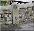
OS Bench Mark, Bescar Lane
Listed as an altitude of 13.4m above Ordnance Datum.
Image: © Keith Edkins
Taken: 8 Mar 2018
0.03 miles
2
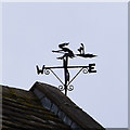
Weather vane, Bescar Lane
There is more than one witch vane around here, presumably they are a reference to the Pendle witches tried in 1612. Pendle Hill is a mere 30 miles away as the broomstick flies.
Image: © Keith Edkins
Taken: 8 Mar 2018
0.10 miles
4
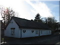
Old Cottage
17th Century or possibly earlier cruck framed Grade 2 listed building. It used to be two thatched cottages and was subsequently covered with a tin roof but is now slated.
Image: © Michael Alley
Taken: 24 Feb 2012
0.13 miles
6
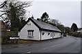
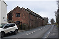
Cottages in Bescar Brow Lane
Originally two cottages, C17 or earlier, now combined and the front wall rebuilt in brick. Grade II listed.
Image: © Keith Edkins
Taken: 8 Mar 2018
0.15 miles
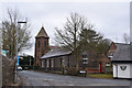
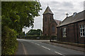
7
St Elizabeths Parish Centre and beyond its associated church
Image: © Michael Alley
Taken: 24 Feb 2012
0.16 miles
8
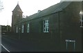
Hall Road - Bescar (near St Elizabeth's Church)
Image: © Anthony Parkes
Taken: 30 Nov 2013
0.16 miles
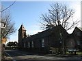
9
St Elizabeth's RC Church with St Mary's pre-school centre in the foreground
Image: © Ian Greig
Taken: 7 Sep 2012
0.17 miles
10
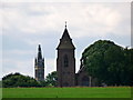
The two towers
View from Bescar Lane looking towards St Elizabeth's Church and Scarisbrick Hall.
Image: © Paul Charlesworth
Taken: 20 Jul 2009
0.18 miles