IMAGES TAKEN NEAR TO
Lordsgate Lane, ORMSKIRK, L40 7ST
Introduction
This page details the photographs taken nearby to Lordsgate Lane, L40 7ST by members of the Geograph project.
The Geograph project started in 2005 with the aim of publishing, organising and preserving representative images for every square kilometre of Great Britain, Ireland and the Isle of Man.

There are currently over 7.5m images from over14,400 individuals and you can help contribute to the project by visiting https://www.geograph.org.uk
Image Map
Images are licensed for reuse under creativecommons.org/licenses/by-sa/2.0
Notes
- Clicking on the map will re-center to the selected point.
- The higher the marker number, the further away the image location is from the centre of the postcode.
Image Listing (32 Images Found)
Images are licensed for reuse under creativecommons.org/licenses/by-sa/2.0
Image
Details
Distance
4
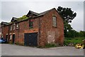
Rights of Way Act 1932 Notice
On Lordsgate Lane.
Image: © Ian S
Taken: 22 May 2015
0.11 miles
6

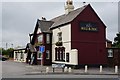
Bull & Dog, Burscough
The pub on Liverpool Road predated a lot of the surrounding development.
Image: © Bill Boaden
Taken: 19 Aug 2023
0.13 miles
7
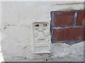
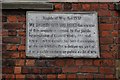
Ordnance Survey Flush Bracket G2500
This heavily over-painted bracket can be found on a house wall in Liverpool Road South, Burscough.
For more detail see : http://www.bench-marks.org.uk/bm14730
Image: © Peter Wood
Taken: 31 Aug 2014
0.14 miles
8

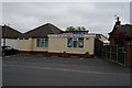
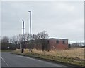
New housing development at Burscough
This was a brownfield site
Image: © Bill Boaden
Taken: 19 Aug 2023
0.16 miles
9
Wartime Relic from Burscough Airfield
Image: © Anthony Parkes
Taken: 1 Feb 2014
0.16 miles
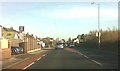
10
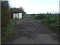
Gated track off Tollgate Road
Looking east.
Image: © JThomas
Taken: 25 Oct 2014
0.17 miles