IMAGES TAKEN NEAR TO
Elm Road, ORMSKIRK, L40 7RJ
Introduction
This page details the photographs taken nearby to Elm Road, L40 7RJ by members of the Geograph project.
The Geograph project started in 2005 with the aim of publishing, organising and preserving representative images for every square kilometre of Great Britain, Ireland and the Isle of Man.

There are currently over 7.5m images from over14,400 individuals and you can help contribute to the project by visiting https://www.geograph.org.uk
Image Map
Images are licensed for reuse under creativecommons.org/licenses/by-sa/2.0
Notes
- Clicking on the map will re-center to the selected point.
- The higher the marker number, the further away the image location is from the centre of the postcode.
Image Listing (7 Images Found)
Images are licensed for reuse under creativecommons.org/licenses/by-sa/2.0
Image
Details
Distance
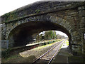
1
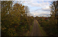
A single track line viewed from Square Lane railway bridge
Image: © Ian Greig
Taken: 4 Nov 2011
0.13 miles
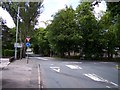
3
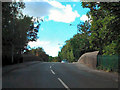
Square Lane (A5209)
Mini roundabout at the junction of the A5209 with the B5241 (Junction Lane).
Image: © David Dixon
Taken: 25 Sep 2010
0.16 miles
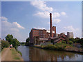
4
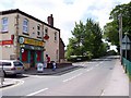
Burscough Post Office on Square Lane
Image: © Raymond Knapman
Taken: 19 May 2011
0.16 miles
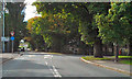
5
Square Lane Railway Bridge
Square Lane (A5209), crossing the railway line before joining Liverpool Road.
Image: © David Dixon
Taken: 25 Sep 2010
0.20 miles
7
Burscough Junction station - road bridge
A skew bridge carrying Junction Lane.
Image: © Stephen Craven
Taken: 24 Mar 2018
0.25 miles