IMAGES TAKEN NEAR TO
Lyelake Lane, ORMSKIRK, L40 6LA
Introduction
This page details the photographs taken nearby to Lyelake Lane, L40 6LA by members of the Geograph project.
The Geograph project started in 2005 with the aim of publishing, organising and preserving representative images for every square kilometre of Great Britain, Ireland and the Isle of Man.

There are currently over 7.5m images from over14,400 individuals and you can help contribute to the project by visiting https://www.geograph.org.uk
Image Map
Images are licensed for reuse under creativecommons.org/licenses/by-sa/2.0
Notes
- Clicking on the map will re-center to the selected point.
- The higher the marker number, the further away the image location is from the centre of the postcode.
Image Listing (9 Images Found)
Images are licensed for reuse under creativecommons.org/licenses/by-sa/2.0
Image
Details
Distance
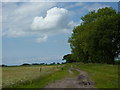
2
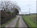
Footpath across Lyelake Lane between Grapel's Farm and Wiswall's Farm
The wagon belongs to Alfred Price and Sons (Liverpool) Fruit and vegetables
Image: © Gary Rogers
Taken: 25 Feb 2016
0.04 miles
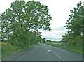

5
Footpath between Wiswall's Farm and Goose Brook
The water tower at Scarth Hill can be seen in the distance
Image: © Gary Rogers
Taken: 25 Feb 2016
0.16 miles
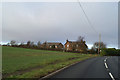
6
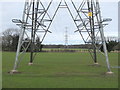
Line of Pylons near Grapel's Farm, Blaguegate
Image: © Gary Rogers
Taken: 25 Feb 2016
0.18 miles