IMAGES TAKEN NEAR TO
Crosshall Brow, L40 6AD
Introduction
This page details the photographs taken nearby to Crosshall Brow, L40 6AD by members of the Geograph project.
The Geograph project started in 2005 with the aim of publishing, organising and preserving representative images for every square kilometre of Great Britain, Ireland and the Isle of Man.

There are currently over 7.5m images from over14,400 individuals and you can help contribute to the project by visiting https://www.geograph.org.uk
Image Map
Images are licensed for reuse under creativecommons.org/licenses/by-sa/2.0
Notes
- Clicking on the map will re-center to the selected point.
- The higher the marker number, the further away the image location is from the centre of the postcode.
Image Listing (21 Images Found)
Images are licensed for reuse under creativecommons.org/licenses/by-sa/2.0
Image
Details
Distance
1
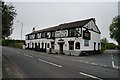
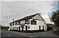
The Halton Castle, Westhead
http://www.geograph.org.uk/photo/4498400
Image: © Ian S
Taken: 22 May 2015
0.01 miles
2
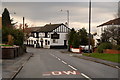
The Halton Castle, Westhead, Ormskirk
Image: © Mike Pennington
Taken: 22 Nov 2015
0.01 miles
3
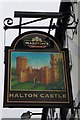
The Halton Castle, Westhead
http://www.geograph.org.uk/photo/4498398
Image: © Ian S
Taken: 22 May 2015
0.02 miles
7
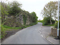
Castle Lane, Westhead at dismantled railway bridge
Image: © Gary Rogers
Taken: 19 Apr 2017
0.08 miles
8
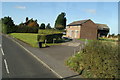
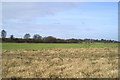
Mawdsley's Farm, beside Crosshall Brow (A577)
As seen from the top deck of the 375 Wigan - Southport bus.
Image: © David Long
Taken: 16 Oct 2009
0.12 miles
9
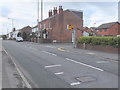
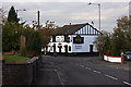
Speed camera, A577 Wigan Road, Westhead
At junction of Wigan Road and Halton Chase near the Prince Albert pub
Image: © Gary Rogers
Taken: 5 Mar 2016
0.13 miles
10
Short term planning
The abandoned railway from Ormskirk to Wigan via Skelmersdale.
Image: © David Long
Taken: 17 Feb 2006
0.18 miles