IMAGES TAKEN NEAR TO
Ellerbrook Drive, ORMSKIRK, L40 5SZ
Introduction
This page details the photographs taken nearby to Ellerbrook Drive, L40 5SZ by members of the Geograph project.
The Geograph project started in 2005 with the aim of publishing, organising and preserving representative images for every square kilometre of Great Britain, Ireland and the Isle of Man.

There are currently over 7.5m images from over14,400 individuals and you can help contribute to the project by visiting https://www.geograph.org.uk
Image Map
Images are licensed for reuse under creativecommons.org/licenses/by-sa/2.0
Notes
- Clicking on the map will re-center to the selected point.
- The higher the marker number, the further away the image location is from the centre of the postcode.
Image Listing (6 Images Found)
Images are licensed for reuse under creativecommons.org/licenses/by-sa/2.0
Image
Details
Distance
1
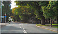
Square Lane (A5209)
Mini roundabout at the junction of the A5209 with the B5241 (Junction Lane).
Image: © David Dixon
Taken: 25 Sep 2010
0.09 miles
3
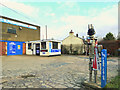
The Fabricator
Outside Lathom Motorcraft, Briars Lane, Lathom
Image: © Gary Rogers
Taken: 31 Jan 2015
0.20 miles
4
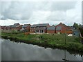
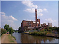
Canalside houses, Glovers Way, Burscough
Looking south from Junction Bridge.
Image: © Christine Johnstone
Taken: 24 May 2021
0.23 miles
5
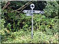
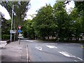
Signpost on the Leeds to Liverpool canal
Image: © Norman Caesar
Taken: 25 Aug 2017
0.23 miles