IMAGES TAKEN NEAR TO
Bleak Lane, ORMSKIRK, L40 4BP
Introduction
This page details the photographs taken nearby to Bleak Lane, L40 4BP by members of the Geograph project.
The Geograph project started in 2005 with the aim of publishing, organising and preserving representative images for every square kilometre of Great Britain, Ireland and the Isle of Man.

There are currently over 7.5m images from over14,400 individuals and you can help contribute to the project by visiting https://www.geograph.org.uk
Image Map
Images are licensed for reuse under creativecommons.org/licenses/by-sa/2.0
Notes
- Clicking on the map will re-center to the selected point.
- The higher the marker number, the further away the image location is from the centre of the postcode.
Image Listing (21 Images Found)
Images are licensed for reuse under creativecommons.org/licenses/by-sa/2.0
Image
Details
Distance
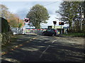
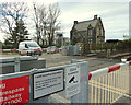
2
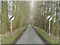
Approaching Four Lane Ends Level Crossing
On Meadow Lane heading south.
Image: © JThomas
Taken: 25 Oct 2014
0.05 miles
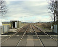
4
Railway towards Manchester
Looking south east from Four Lane Ends Level Crossing.
Image: © JThomas
Taken: 25 Oct 2014
0.09 miles
5
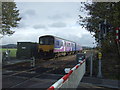
Train passing Four Lane Ends Level Crossing
Northern Rail Class 150, No 150114 bound for Manchester Airport.
Image: © JThomas
Taken: 25 Oct 2014
0.09 miles
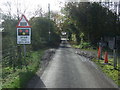
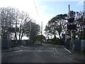
6
Four Lane Ends Level Crossing, Lathom
Image: © Alexander P Kapp
Taken: 7 Jun 2011
0.10 miles
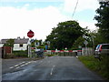
7
Four Lane Ends Level Crossing
Barriers down, train approaching.
Image: © JThomas
Taken: 25 Oct 2014
0.10 miles
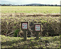
8
Four Lane Ends Level Crossing
On Meadow Lane heading south.
Image: © JThomas
Taken: 25 Oct 2014
0.10 miles
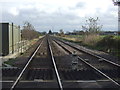
10
Level Crossing at Four Lane Ends, towards Hoscar
Image: © Gary Rogers
Taken: 18 Feb 2015
0.10 miles