IMAGES TAKEN NEAR TO
Bentley Lane, ORMSKIRK, L40 3SN
Introduction
This page details the photographs taken nearby to Bentley Lane, L40 3SN by members of the Geograph project.
The Geograph project started in 2005 with the aim of publishing, organising and preserving representative images for every square kilometre of Great Britain, Ireland and the Isle of Man.

There are currently over 7.5m images from over14,400 individuals and you can help contribute to the project by visiting https://www.geograph.org.uk
Image Map
Images are licensed for reuse under creativecommons.org/licenses/by-sa/2.0
Notes
- Clicking on the map will re-center to the selected point.
- The higher the marker number, the further away the image location is from the centre of the postcode.
Image Listing (13 Images Found)
Images are licensed for reuse under creativecommons.org/licenses/by-sa/2.0
Image
Details
Distance
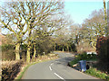
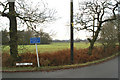
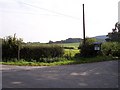
3
Junction of Bentley Lane and Jackson's Lane, Hilldale
Image: © Gary Rogers
Taken: 7 Feb 2015
0.06 miles
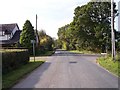
4
Path between Bentley Lane and Old Lane, Hilldale
Image: © Gary Rogers
Taken: 9 Mar 2017
0.07 miles
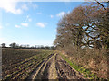
6
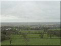
View towards Six Foxes from Old Mill Lane
Image: © Gary Rogers
Taken: 27 Jan 2015
0.16 miles
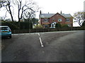
8
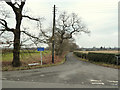
Junction of Moody Lane and Bentley Lane, Hilldale
Image: © Gary Rogers
Taken: 7 Feb 2015
0.20 miles
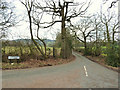
9
Public footpath sign on Bentley Lane
The track leads to Gauger's Farm
Image: © Raymond Knapman
Taken: 13 Oct 2010
0.22 miles
10
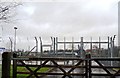
National Grid Compound on Moody Lane
Image: © Anthony Parkes
Taken: 15 Feb 2014
0.24 miles