IMAGES TAKEN NEAR TO
Catharines Lane, ORMSKIRK, L39 9EL
Introduction
This page details the photographs taken nearby to Catharines Lane, L39 9EL by members of the Geograph project.
The Geograph project started in 2005 with the aim of publishing, organising and preserving representative images for every square kilometre of Great Britain, Ireland and the Isle of Man.

There are currently over 7.5m images from over14,400 individuals and you can help contribute to the project by visiting https://www.geograph.org.uk
Image Map
Images are licensed for reuse under creativecommons.org/licenses/by-sa/2.0
Notes
- Clicking on the map will re-center to the selected point.
- The higher the marker number, the further away the image location is from the centre of the postcode.
Image Listing (8 Images Found)
Images are licensed for reuse under creativecommons.org/licenses/by-sa/2.0
Image
Details
Distance
3
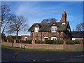
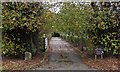
Cottages on Croppers Lane at Moss End
Image: © Raymond Knapman
Taken: 15 Nov 2010
0.13 miles
4
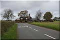
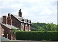
Cottage on the corner of Long Lane and Cropper's Lane, between Aughton and Bickerstaffe
Image: © Mike Pennington
Taken: 16 Nov 2015
0.13 miles
5
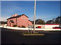
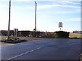
The Dogtel at Moss End
Posh named dog kennels
Image: © Raymond Knapman
Taken: 15 Nov 2010
0.17 miles
6
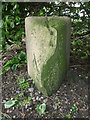
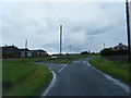
Old Boundary Marker by Long Lane, Aughton Parish
Parish Boundary Marker by the UC road, in parish of Aughton (West Lancashire District), Long Lane, at junction with farm drive, 75m South of junction with Cropper's Lane.
Surveyed
Milestone Society National ID: LA_AUGBIC03pb
Image: © Milestone Society
Taken: Unknown
0.18 miles