IMAGES TAKEN NEAR TO
Carr Moss Lane, ORMSKIRK, L39 8RU
Introduction
This page details the photographs taken nearby to Carr Moss Lane, L39 8RU by members of the Geograph project.
The Geograph project started in 2005 with the aim of publishing, organising and preserving representative images for every square kilometre of Great Britain, Ireland and the Isle of Man.

There are currently over 7.5m images from over14,400 individuals and you can help contribute to the project by visiting https://www.geograph.org.uk
Image Map
Images are licensed for reuse under creativecommons.org/licenses/by-sa/2.0
Notes
- Clicking on the map will re-center to the selected point.
- The higher the marker number, the further away the image location is from the centre of the postcode.
Image Listing (10 Images Found)
Images are licensed for reuse under creativecommons.org/licenses/by-sa/2.0
Image
Details
Distance

2
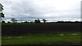
Farmland near Halsall
Vast open fields near Halsall.
Image: © Peter Mackenzie
Taken: 16 May 2017
0.13 miles
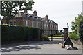
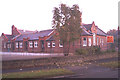
5
Lollipop Lady at Halsall St Cuthbert's Primary School
New Street, Halsall
Image: © Gary Rogers
Taken: 10 Mar 2016
0.14 miles
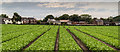
7
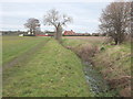
Footpath between Plex Moss Lane and Carr Moss Lane
Image: © Gary Rogers
Taken: 10 Mar 2016
0.19 miles
8
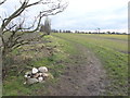
Footpath between Carr Moss Lane and Plex Moss Lane
Image: © Gary Rogers
Taken: 10 Mar 2016
0.21 miles
9
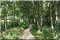
Bishop's Walk, Halsall Wildlife and Nature Area
Off New Street, Halsall
Image: © Gary Rogers
Taken: 10 Mar 2016
0.23 miles
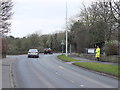
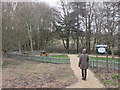
10
Halsall Wildlife and Nature Area
A very small area of trees next to the school.
Image: © Mike Pennington
Taken: 3 Jul 2015
0.23 miles