IMAGES TAKEN NEAR TO
Narrow Lane, ORMSKIRK, L39 7HD
Introduction
This page details the photographs taken nearby to Narrow Lane, L39 7HD by members of the Geograph project.
The Geograph project started in 2005 with the aim of publishing, organising and preserving representative images for every square kilometre of Great Britain, Ireland and the Isle of Man.

There are currently over 7.5m images from over14,400 individuals and you can help contribute to the project by visiting https://www.geograph.org.uk
Image Map
Images are licensed for reuse under creativecommons.org/licenses/by-sa/2.0
Notes
- Clicking on the map will re-center to the selected point.
- The higher the marker number, the further away the image location is from the centre of the postcode.
Image Listing (17 Images Found)
Images are licensed for reuse under creativecommons.org/licenses/by-sa/2.0
Image
Details
Distance
1
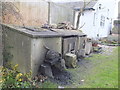
Coal bunkers behind houses on Booth's Lane
Image: © Gary Rogers
Taken: 3 Mar 2016
0.04 miles
2
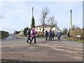
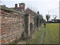
Walkers on Fir Tree Lane, Clieve's Hills
Image: © Gary Rogers
Taken: 3 Mar 2016
0.04 miles
5
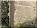
Ordnance Survey benchmark
On house on Fir Tree Lane, Clieve's Hills
Image: © Gary Rogers
Taken: 3 Mar 2016
0.08 miles
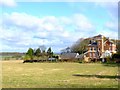
6
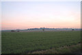
North from Clieves Hills Farm
Open fields dominate the view to the horizon.
Image: © Peter Mackenzie
Taken: 18 Jul 2017
0.08 miles
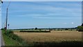
8
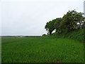
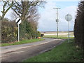
Crop field and hedgerow north off Shepherd's Lane
Image: © JThomas
Taken: 28 Apr 2019
0.11 miles