IMAGES TAKEN NEAR TO
Rothwell Drive, ORMSKIRK, L39 5AW
Introduction
This page details the photographs taken nearby to Rothwell Drive, L39 5AW by members of the Geograph project.
The Geograph project started in 2005 with the aim of publishing, organising and preserving representative images for every square kilometre of Great Britain, Ireland and the Isle of Man.

There are currently over 7.5m images from over14,400 individuals and you can help contribute to the project by visiting https://www.geograph.org.uk
Image Map
Images are licensed for reuse under creativecommons.org/licenses/by-sa/2.0
Notes
- Clicking on the map will re-center to the selected point.
- The higher the marker number, the further away the image location is from the centre of the postcode.
Image Listing (13 Images Found)
Images are licensed for reuse under creativecommons.org/licenses/by-sa/2.0
Image
Details
Distance
1
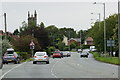
The A59 in Aughton
Here named Liverpool Road. Christ Church Aughton is in the distance.
Image: © Mike Pennington
Taken: 6 Aug 2011
0.05 miles
2
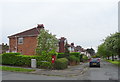
Houses on Liverpool Road, Ormskirk
Showing position of Postbox No. L39 92.
See Image] for postbox.
Image: © JThomas
Taken: 28 Apr 2019
0.06 miles
3
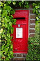
Elizabeth II postbox on Liverpool Road, Ormskirk
Postbox No. L39 92.
See Image] for context.
Image: © JThomas
Taken: 28 Apr 2019
0.06 miles
5
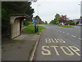
Bus stop and shelter on Liverpool Road, Aughton
Image: © JThomas
Taken: 28 Apr 2019
0.08 miles
6
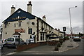
The Royal Oak, Liverpool Road, Aughton
Image: © Mike Pennington
Taken: 6 Aug 2011
0.08 miles
8
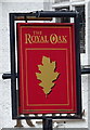
Sign for the Royal Oak, Aughton
See Image] for context.
Image: © JThomas
Taken: 28 Apr 2019
0.08 miles
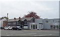
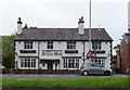
9
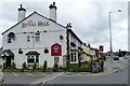
The Royal Oak, Aughton
A public house on Liverpool Road.
Image: © Mat Fascione
Taken: 27 Jun 2016
0.10 miles
10
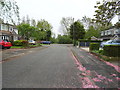
Standhouse Lane, Aughton
Looking south east.
Image: © JThomas
Taken: 28 Apr 2019
0.11 miles