IMAGES TAKEN NEAR TO
Bridge Street, ORMSKIRK, L39 4RH
Introduction
This page details the photographs taken nearby to Bridge Street, L39 4RH by members of the Geograph project.
The Geograph project started in 2005 with the aim of publishing, organising and preserving representative images for every square kilometre of Great Britain, Ireland and the Isle of Man.

There are currently over 7.5m images from over14,400 individuals and you can help contribute to the project by visiting https://www.geograph.org.uk
Image Map
Images are licensed for reuse under creativecommons.org/licenses/by-sa/2.0
Notes
- Clicking on the map will re-center to the selected point.
- The higher the marker number, the further away the image location is from the centre of the postcode.
Image Listing (87 Images Found)
Images are licensed for reuse under creativecommons.org/licenses/by-sa/2.0
Image
Details
Distance
1
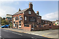
The Greyhound, Ormskirk
A public house on Aughton Street at Ormskirk.
Image: © David Dixon
Taken: 22 Sep 2020
0.07 miles
2
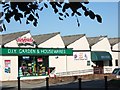
Hesfords, Ormskirk
Former agricultural machinery factory, converted into a DIY store and snooker hall.
Image: © Bryan Pready
Taken: 15 May 2008
0.07 miles
3
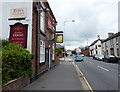
The Greyhound Inn, Ormskirk
A public house along Aughton Street.
Image: © Mat Fascione
Taken: 27 Jun 2016
0.08 miles
5
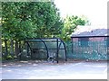
Ormskirk's best-kept secret!
The local Council has hidden these covered cycle stands in a corner of a car park where no-one is likely to find them. Most local cyclists certainly don't know they exist and wouldn't use them if they did because they're too far from the shops.
Image: © Bryan Pready
Taken: 15 May 2008
0.11 miles
6
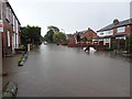
Flooding in Dyers Lane
Heavy and prolonged rain resulted in flooding in Dyers Lane, for the first time in many years. By the time this photo was taken, Hurlston Brook, which runs alongside Dyers Lane, was overflowing. Some residents have been evacuated.
Image: © Bryan Pready
Taken: 25 Sep 2012
0.11 miles
7
Old Boundary Marker on the B5197 Aughton Street, in Ormskirk
Parish Boundary Marker inscribed in the centre pier of Brook Bridge on the southeast side of the B5197 Aughton Street, Ormskirk. On the former boundary of Ormskirk and Aughton parishes, entirely in Ormskirk from 1931 and an unparished area from 1974. The effaced inscriptions were probably Ormskirk and Aughton.
Milestone Society National ID: LA_ORMSK01pb
Image: © N Upton
Taken: 1 Mar 2023
0.11 miles
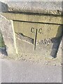
9
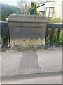
Old Bridge Marker on the B5197 Aughton Street in Ormskirk
Bridge Marker inscribed in the centre pier of Brook Bridge on the northwest side of the B5197 Aughton Street in Ormskirk.
Milestone Society National ID: LA_ORMSK02br
Image: © N Upton
Taken: 1 Mar 2023
0.11 miles
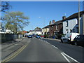
10
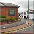
Park Road, Ormskirk
The back end of M&S and the street leading to the Market Hall.
Image: © Gerald England
Taken: 16 Jul 2010
0.12 miles