IMAGES TAKEN NEAR TO
Altys Lane, ORMSKIRK, L39 4RG
Introduction
This page details the photographs taken nearby to Altys Lane, L39 4RG by members of the Geograph project.
The Geograph project started in 2005 with the aim of publishing, organising and preserving representative images for every square kilometre of Great Britain, Ireland and the Isle of Man.

There are currently over 7.5m images from over14,400 individuals and you can help contribute to the project by visiting https://www.geograph.org.uk
Image Map
Images are licensed for reuse under creativecommons.org/licenses/by-sa/2.0
Notes
- Clicking on the map will re-center to the selected point.
- The higher the marker number, the further away the image location is from the centre of the postcode.
Image Listing (6 Images Found)
Images are licensed for reuse under creativecommons.org/licenses/by-sa/2.0
Image
Details
Distance
1
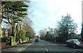
Ribbon Development
Inter-war houses along Alty's Lane, Ormskirk, with views across green-belt farmland at front and rear.
Image: © Bryan Pready
Taken: 12 Nov 2008
0.08 miles
2
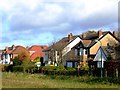
Ormskirk Cricket Club
With houses on Brook Lane beyond.
Image: © Bryan Pready
Taken: 12 Nov 2008
0.15 miles
3

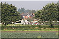
Ormskirk Cricket Club
The start and finish point for the Ormskirk 10k race - several hundred eager souls waiting for the mass start.
Image: © Chris Denny
Taken: 21 Sep 2008
0.18 miles
4
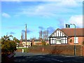
Ormskirk Cricket Club
A view across the fields from St Helens Road
Image: © Chris Denny
Taken: 21 Sep 2008
0.21 miles
5
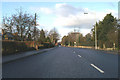
The St Helens Road into Ormskirk
The A570.
Image: © David Long
Taken: 27 Dec 2005
0.22 miles