IMAGES TAKEN NEAR TO
Chapel Street, ORMSKIRK, L39 4QF
Introduction
This page details the photographs taken nearby to Chapel Street, L39 4QF by members of the Geograph project.
The Geograph project started in 2005 with the aim of publishing, organising and preserving representative images for every square kilometre of Great Britain, Ireland and the Isle of Man.

There are currently over 7.5m images from over14,400 individuals and you can help contribute to the project by visiting https://www.geograph.org.uk
Image Map
Images are licensed for reuse under creativecommons.org/licenses/by-sa/2.0
Notes
- Clicking on the map will re-center to the selected point.
- The higher the marker number, the further away the image location is from the centre of the postcode.
Image Listing (89 Images Found)
Images are licensed for reuse under creativecommons.org/licenses/by-sa/2.0
Image
Details
Distance
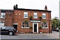
3
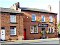
O'Este Restaurant
This restaurant on Chapel Street was previously the "Cricketers" pub.
Image: © Bryan Pready
Taken: 12 Nov 2008
0.05 miles
4
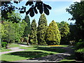
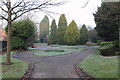
Victoria Park, Ormskirk
An extremely pleasant triangle of gardens bounded on two sides by busy main roads. The obelisk of the war memorial is just visible in the middle distance.
Image: © Chris Denny
Taken: 20 Jun 2010
0.06 miles
5
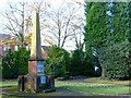
War Memorial
This monument commemorates a local man, Sgt-Major Nunnerley, who was a survivor of the "600" who took part in the Charge of the Light Brigade at the Battle of Balaclava in the Crimea in 1854, and three others who died in South Africa during the Boer War.
Image: © Bryan Pready
Taken: 12 Nov 2008
0.06 miles
6
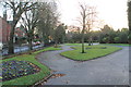
Victoria Park in winter
Blue and yellow pansies in the flower beds this year. The small park is triangular, bordered by St. Helens Road, Knowsley Road and Ruff Lane; the latter is visible on the left of the picture
Image: © K A
Taken: 23 Nov 2012
0.07 miles
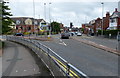
7
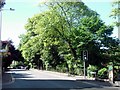
St Helens Road, Ormskirk
St Helens Road, Ormskirk, at the junction with Park Road.
Image: © David Dixon
Taken: 17 Sep 2010
0.07 miles
8
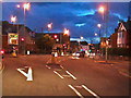
Ormskirk Junction
Box junction at the corner of St Helens Road and Park Road.
Image: © Gerald England
Taken: 19 Aug 2011
0.07 miles
9
A wintery Victoria Park
A light frost covers the ground on a cold winter morninig
Image: © K A
Taken: 30 Nov 2012
0.07 miles
10
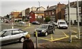
Knowsley Road, Ormskirk
The final section of Ormskirk's maddening one way system for those heading south, with traffic lights where they are not needed and a potentially lethal junction at the far end where they would be much more useful. On a Sunday morning however all is quiet.
Image: © Chris Denny
Taken: 20 Jun 2010
0.08 miles