IMAGES TAKEN NEAR TO
Cottage Mews, Cottage Lane, ORMSKIRK, L39 3NZ
Introduction
This page details the photographs taken nearby to Cottage Mews, Cottage Lane, L39 3NZ by members of the Geograph project.
The Geograph project started in 2005 with the aim of publishing, organising and preserving representative images for every square kilometre of Great Britain, Ireland and the Isle of Man.

There are currently over 7.5m images from over14,400 individuals and you can help contribute to the project by visiting https://www.geograph.org.uk
Image Map
Images are licensed for reuse under creativecommons.org/licenses/by-sa/2.0
Notes
- Clicking on the map will re-center to the selected point.
- The higher the marker number, the further away the image location is from the centre of the postcode.
Image Listing (17 Images Found)
Images are licensed for reuse under creativecommons.org/licenses/by-sa/2.0
Image
Details
Distance
6
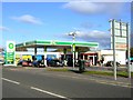
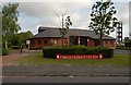
BP petrol station
One of only two remaining in Ormskirk; the other is Image
Image: © Bryan Pready
Taken: 31 Oct 2008
0.17 miles
7
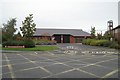
Ormskirk fire station
Ormskirk fire station, County Road, Ormskirk, Lancashire.
Image: © Kevin Hale
Taken: 22 Oct 2006
0.20 miles
8

Hurlston Brook
In full flood after 24 hours of heavy rain.
Image: © Bryan Pready
Taken: 25 Sep 2012
0.20 miles