IMAGES TAKEN NEAR TO
Cedar Crescent, ORMSKIRK, L39 3NT
Introduction
This page details the photographs taken nearby to Cedar Crescent, L39 3NT by members of the Geograph project.
The Geograph project started in 2005 with the aim of publishing, organising and preserving representative images for every square kilometre of Great Britain, Ireland and the Isle of Man.

There are currently over 7.5m images from over14,400 individuals and you can help contribute to the project by visiting https://www.geograph.org.uk
Image Map
Images are licensed for reuse under creativecommons.org/licenses/by-sa/2.0
Notes
- Clicking on the map will re-center to the selected point.
- The higher the marker number, the further away the image location is from the centre of the postcode.
Image Listing (12 Images Found)
Images are licensed for reuse under creativecommons.org/licenses/by-sa/2.0
Image
Details
Distance
1
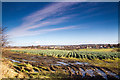
On Gaw Hill
A telephoto shot from Gaw Hill looking over Holborn Hill towards Ormskirk Parish church.
Image: © Chris Denny
Taken: 4 Feb 2015
0.04 miles
2
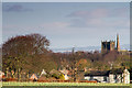
Ormskirk from the west
A broad view of the town from near the top of Gaw Hill. A solitary worker is picking leeks from the field.
Image: © Chris Denny
Taken: 4 Feb 2015
0.08 miles
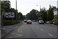
4
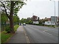
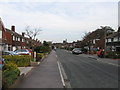
Holborn Hill, Ormskirk
Looking south west on the A59.
Image: © JThomas
Taken: 28 Apr 2019
0.13 miles
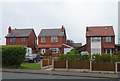
8
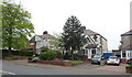
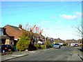
Houses on Holborn Hill, Ormskirk
One being dwarfed by a monkey puzzle tree.
Image: © JThomas
Taken: 28 Apr 2019
0.22 miles
9
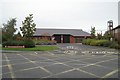
Ormskirk fire station
Ormskirk fire station, County Road, Ormskirk, Lancashire.
Image: © Kevin Hale
Taken: 22 Oct 2006
0.23 miles