IMAGES TAKEN NEAR TO
Turnpike Road, ORMSKIRK, L39 3LD
Introduction
This page details the photographs taken nearby to Turnpike Road, L39 3LD by members of the Geograph project.
The Geograph project started in 2005 with the aim of publishing, organising and preserving representative images for every square kilometre of Great Britain, Ireland and the Isle of Man.

There are currently over 7.5m images from over14,400 individuals and you can help contribute to the project by visiting https://www.geograph.org.uk
Image Map
Images are licensed for reuse under creativecommons.org/licenses/by-sa/2.0
Notes
- Clicking on the map will re-center to the selected point.
- The higher the marker number, the further away the image location is from the centre of the postcode.
Image Listing (8 Images Found)
Images are licensed for reuse under creativecommons.org/licenses/by-sa/2.0
Image
Details
Distance
3
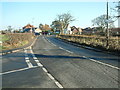
Northway
The A59 towards Liverpool - looking south west.
Image: © JThomas
Taken: 28 Apr 2019
0.14 miles
4
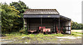
Georgeson's Farm
Barn at Georgeson's Farm.
Image: © Peter McDermott
Taken: 24 Sep 2016
0.17 miles
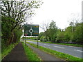
5

An Ent starts its weary trudge down Fir Tree Lane
Image: © Ian Greig
Taken: 23 Jul 2012
0.19 miles
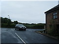
8
Roundabout at the junction of Turnpike Road and the A59
Image: © Alexander P Kapp
Taken: 21 Aug 2007
0.20 miles