IMAGES TAKEN NEAR TO
Asmall Lane, ORMSKIRK, L39 3BG
Introduction
This page details the photographs taken nearby to Asmall Lane, L39 3BG by members of the Geograph project.
The Geograph project started in 2005 with the aim of publishing, organising and preserving representative images for every square kilometre of Great Britain, Ireland and the Isle of Man.

There are currently over 7.5m images from over14,400 individuals and you can help contribute to the project by visiting https://www.geograph.org.uk
Image Map
Images are licensed for reuse under creativecommons.org/licenses/by-sa/2.0
Notes
- Clicking on the map will re-center to the selected point.
- The higher the marker number, the further away the image location is from the centre of the postcode.
Image Listing (11 Images Found)
Images are licensed for reuse under creativecommons.org/licenses/by-sa/2.0
Image
Details
Distance
3
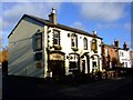
Eureka!
The Eureka pub, in Halsall Lane, Ormskirk.
Image: © Bryan Pready
Taken: 12 Nov 2008
0.09 miles
4
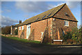
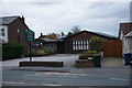
Second life
A well converted barn on the edge of Ormskirk
Image: © David Long
Taken: 27 Dec 2005
0.09 miles

9
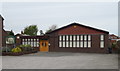
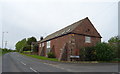
Cottage Lane Mission, Ormskirk
An evangelical church in Ormskirk.
Image: © JThomas
Taken: 28 Apr 2019
0.18 miles