IMAGES TAKEN NEAR TO
Charlesbye Avenue, ORMSKIRK, L39 2XY
Introduction
This page details the photographs taken nearby to Charlesbye Avenue, L39 2XY by members of the Geograph project.
The Geograph project started in 2005 with the aim of publishing, organising and preserving representative images for every square kilometre of Great Britain, Ireland and the Isle of Man.

There are currently over 7.5m images from over14,400 individuals and you can help contribute to the project by visiting https://www.geograph.org.uk
Image Map
Images are licensed for reuse under creativecommons.org/licenses/by-sa/2.0
Notes
- Clicking on the map will re-center to the selected point.
- The higher the marker number, the further away the image location is from the centre of the postcode.
Image Listing (16 Images Found)
Images are licensed for reuse under creativecommons.org/licenses/by-sa/2.0
Image
Details
Distance
1
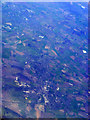
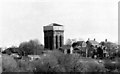
Ormskirk from the air
Ormskirk is at the bottom of the photo,with Maghull to the top left. Viewed from a Heathrow bound flight from Glasgow.
Image: © Thomas Nugent
Taken: 10 Apr 2011
0.05 miles
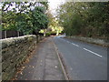
3
Dark Lane Bridge
The disused railway bridge for the Ormskirk to Skelmersdale railway that ran up until the 1960's. Dark Lane, Ormskirk.
Image: © Gary Rogers
Taken: 5 Oct 2013
0.10 miles
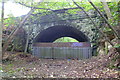
4
Dark Lane railway bridge
The footpath in the cutting of the long closed Omskirk to St Helens railway comes to an abrupt halt at the bridge. Beyond this point are signs warning of private land.
Image: © Chris Denny
Taken: 29 Mar 2009
0.10 miles
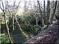
5
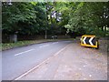
The double bend over the dismantled Ormskirk to Skelmersdale railway
The bridge has an end-on junction of Dark Lane and Greetby Hill.
Image: © Raymond Knapman
Taken: 19 May 2011
0.11 miles
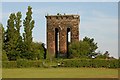
8
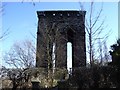
Ormskirk's other water tower
Locally, Ormskirk is well known for the concrete, mushroom shaped water tower on Scarth Hill. Less well known is this one just off Greetby Hill. The photograph was taken in 1987 when the tower was not quite as derelict as it is now Image
Image: © Chris Denny
Taken: Unknown
0.14 miles
10
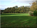
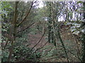
Park and woodland north of Greetby Hill
The trees mark the line of a disused railway.
Image: © JThomas
Taken: 25 Oct 2014
0.15 miles