IMAGES TAKEN NEAR TO
Burscough Street, ORMSKIRK, L39 2EY
Introduction
This page details the photographs taken nearby to Burscough Street, L39 2EY by members of the Geograph project.
The Geograph project started in 2005 with the aim of publishing, organising and preserving representative images for every square kilometre of Great Britain, Ireland and the Isle of Man.

There are currently over 7.5m images from over14,400 individuals and you can help contribute to the project by visiting https://www.geograph.org.uk
Image Map
Images are licensed for reuse under creativecommons.org/licenses/by-sa/2.0
Notes
- Clicking on the map will re-center to the selected point.
- The higher the marker number, the further away the image location is from the centre of the postcode.
Image Listing (80 Images Found)
Images are licensed for reuse under creativecommons.org/licenses/by-sa/2.0
Image
Details
Distance
1
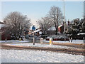
Burscough Street, Ormskirk
Burscough Street and Burscough Road (from where this picture is taken) used to be continuous but since the opening of a trading estate (just off to the left) they have been separated by an offset roundabout which is marginally too small for articulated lorries to negotiate and an utter pain to cross on foot! Still, it looks nice in the snow.
Image: © Chris Denny
Taken: 6 Jan 2010
0.10 miles
3
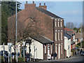
Brandreth House, Burscough Street, Ormskirk
Named after the Doctor who established the nearby dispensary, this Grade II listed building dates from the first half of the nineteenth century and is now lodging rooms. The small building attached to it, now a hairdressers, was formerly a chapel.
Image: © Chris Denny
Taken: 4 Feb 2015
0.11 miles
4
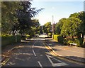
New cycle route
Linking Railway Approach and Station Road.
Image: © Bryan Pready
Taken: 25 Nov 2008
0.12 miles
5
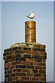
Common Gull (Larus canus), Ormskirk
On a typically Lancastrian brick chimney beside the railway station, part of a building which is probably no longer there.
Image: © Mike Pennington
Taken: 21 Jan 1984
0.13 miles
6
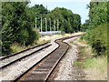
Railway towards Preston
Single-track railway line from Ormskirk, looking northbound towards Preston.
Image: © Paul Charlesworth
Taken: 5 Aug 2009
0.14 miles
7
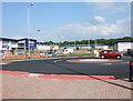
New retail park
Shops and offices have been built on the site shown in Image, where the Hattersley's valves factory used to be.
Image: © Bryan Pready
Taken: 4 Jun 2008
0.14 miles
8
Ormskirk station, line to Preston
The kink in the single track here represents the extant line through the station (formerly southbound track) joining the extant line northwards to Preston (formerly the northbound track)
Image: © Stephen Craven
Taken: 24 Mar 2018
0.14 miles
9
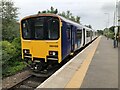
Class 150 DMU at Ormskirk
A Northern service operated by 150122 standing at Ormskirk. The line is separated between the Merseyrail network and the Ormskirk - Preston line necessitating a change of train.
Image: © David Robinson
Taken: 2 Jul 2021
0.14 miles
10
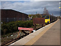
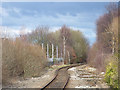
Ormskirk station, division
The line from Liverpool to Preston was cut in two at Ormskirk at some time around 1980. South of here is electrified to Liverpool as can be seen from the third rail here. North to Preston, beyond these buffers, remains diesel-operated. The single platform (originally just for southbound trains) is thus divided into platforms 1 (Liverpool) and 2 (Preston).
Compare my earlier view Image from my only other visit to the station thirty years earlier. A larger stop board has been added to the buffers for trains from Preston.
Image: © Stephen Craven
Taken: 24 Mar 2018
0.14 miles