IMAGES TAKEN NEAR TO
Crosshall Brow, ORMSKIRK, L39 2BE
Introduction
This page details the photographs taken nearby to Crosshall Brow, L39 2BE by members of the Geograph project.
The Geograph project started in 2005 with the aim of publishing, organising and preserving representative images for every square kilometre of Great Britain, Ireland and the Isle of Man.

There are currently over 7.5m images from over14,400 individuals and you can help contribute to the project by visiting https://www.geograph.org.uk
Image Map
Images are licensed for reuse under creativecommons.org/licenses/by-sa/2.0
Notes
- Clicking on the map will re-center to the selected point.
- The higher the marker number, the further away the image location is from the centre of the postcode.
Image Listing (12 Images Found)
Images are licensed for reuse under creativecommons.org/licenses/by-sa/2.0
Image
Details
Distance
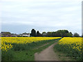
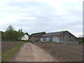
4
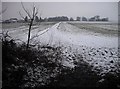
Out of the Ruff
The path leading from Ruff Wood to Cross Hall Brow on the eastern edge of Ormskirk
Image: © Chris Denny
Taken: 21 Feb 2010
0.10 miles
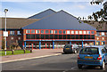
5
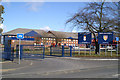
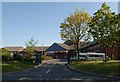
The Knowledge Gateway
Ormskirk School & Sixth Form College, beside the A577 Ormskirk - Skelmersdale road
Image: © David Long
Taken: 5 Mar 2006
0.12 miles
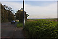
8
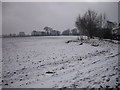
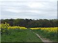
Towards the top of Lady's Walk
A view south near the top of Lady's Walk on the edge of Ormskirk.
Image: © Chris Denny
Taken: 21 Feb 2010
0.16 miles