IMAGES TAKEN NEAR TO
Wigan Road, ORMSKIRK, L39 2AS
Introduction
This page details the photographs taken nearby to Wigan Road, L39 2AS by members of the Geograph project.
The Geograph project started in 2005 with the aim of publishing, organising and preserving representative images for every square kilometre of Great Britain, Ireland and the Isle of Man.

There are currently over 7.5m images from over14,400 individuals and you can help contribute to the project by visiting https://www.geograph.org.uk
Image Map
Images are licensed for reuse under creativecommons.org/licenses/by-sa/2.0
Notes
- Clicking on the map will re-center to the selected point.
- The higher the marker number, the further away the image location is from the centre of the postcode.
Image Listing (18 Images Found)
Images are licensed for reuse under creativecommons.org/licenses/by-sa/2.0
Image
Details
Distance
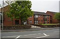
1
Ormskirk & District General Hospital
Image: © Mike Pennington
Taken: 6 Aug 2011
0.06 miles
2
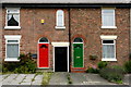
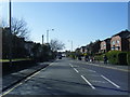
Terraced brick houses, Wigan Road, Ormskirk
Image: © Mike Pennington
Taken: 6 Aug 2011
0.08 miles
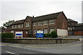
3
Ormskirk & District General Hospital
Image: © Mike Pennington
Taken: 6 Aug 2011
0.09 miles
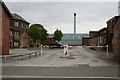
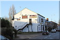
4

House set for demolition, Wigan Road, Ormskirk
Image: © Mike Pennington
Taken: 6 Aug 2011
0.11 miles


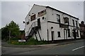
9
The Ropers Arms
Located on Wigan Road, now open again after a period when it was closed, and boarded up
Image: © K A
Taken: 23 Nov 2012
0.18 miles