IMAGES TAKEN NEAR TO
Holly Lane, ORMSKIRK, L39 0HJ
Introduction
This page details the photographs taken nearby to Holly Lane, L39 0HJ by members of the Geograph project.
The Geograph project started in 2005 with the aim of publishing, organising and preserving representative images for every square kilometre of Great Britain, Ireland and the Isle of Man.

There are currently over 7.5m images from over14,400 individuals and you can help contribute to the project by visiting https://www.geograph.org.uk
Image Map
Images are licensed for reuse under creativecommons.org/licenses/by-sa/2.0
Notes
- Clicking on the map will re-center to the selected point.
- The higher the marker number, the further away the image location is from the centre of the postcode.
Image Listing (7 Images Found)
Images are licensed for reuse under creativecommons.org/licenses/by-sa/2.0
Image
Details
Distance
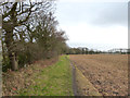
1
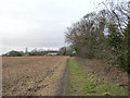
Path near Holly Lane, Rainford Junction
Image: © Gary Rogers
Taken: 26 Jan 2015
0.09 miles
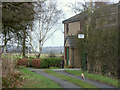
3
Holly Fold Place off Holly Lane, Rainford Junction
Image: © Gary Rogers
Taken: 26 Jan 2015
0.14 miles
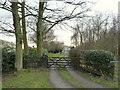
4
House on Private Road off Holly Lane near Rainford Junction
Image: © Gary Rogers
Taken: 26 Jan 2015
0.15 miles
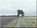
5
Path near Holly Lane, Rainford Junction
Image: © Gary Rogers
Taken: 26 Jan 2015
0.16 miles
6
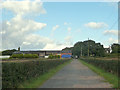
Path to Holly Lane
From the Rainford By Pass passing Holly Fold Farm
Image: © Gary Rogers
Taken: 15 Sep 2015
0.21 miles
7
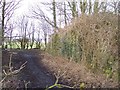
Old railway bridge abutments.
Path to Holly Lane passes the remains of railway between Rainford Junction and Skelmersdale
Image: © Raymond Knapman
Taken: 13 Feb 2009
0.25 miles