IMAGES TAKEN NEAR TO
Lyelake Lane, ORMSKIRK, L39 0EY
Introduction
This page details the photographs taken nearby to Lyelake Lane, L39 0EY by members of the Geograph project.
The Geograph project started in 2005 with the aim of publishing, organising and preserving representative images for every square kilometre of Great Britain, Ireland and the Isle of Man.

There are currently over 7.5m images from over14,400 individuals and you can help contribute to the project by visiting https://www.geograph.org.uk
Image Map
Images are licensed for reuse under creativecommons.org/licenses/by-sa/2.0
Notes
- Clicking on the map will re-center to the selected point.
- The higher the marker number, the further away the image location is from the centre of the postcode.
Image Listing (18 Images Found)
Images are licensed for reuse under creativecommons.org/licenses/by-sa/2.0
Image
Details
Distance
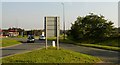
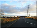
1
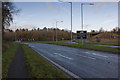
Skelmersdale Road at Four Lane Ends
The road joins a roundabout on Ormskirk Road near the Little Chef.
Image: © Raymond Knapman
Taken: 10 Nov 2010
0.07 miles
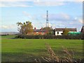
2
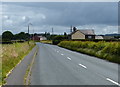
Stanley Farm, near Skelmersdale
The right hand corner of the farmhouse is in square SD4504
Image: © S Parish
Taken: 29 Oct 2005
0.11 miles
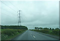
3
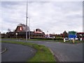
Four Lane Ends Roundabout
North of Junction 3 of the M58.
Image: © Gerald England
Taken: 26 Sep 2008
0.12 miles
6
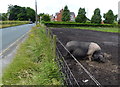
Pig next to Skelmersdale Road near Stanley Farm
Image: © Mat Fascione
Taken: 27 Jun 2016
0.15 miles
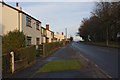
8
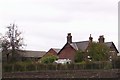
Ormskirk Old Road
These cottages used to be on Ormskirk Road until the highway improvements bypassed them. This shot is taken from a layby on the new road.
Image: © Roger May
Taken: 28 Oct 2005
0.17 miles