IMAGES TAKEN NEAR TO
Mercers Lane, ORMSKIRK, L39 0EJ
Introduction
This page details the photographs taken nearby to Mercers Lane, L39 0EJ by members of the Geograph project.
The Geograph project started in 2005 with the aim of publishing, organising and preserving representative images for every square kilometre of Great Britain, Ireland and the Isle of Man.

There are currently over 7.5m images from over14,400 individuals and you can help contribute to the project by visiting https://www.geograph.org.uk
Image Map
Images are licensed for reuse under creativecommons.org/licenses/by-sa/2.0
Notes
- Clicking on the map will re-center to the selected point.
- The higher the marker number, the further away the image location is from the centre of the postcode.
Image Listing (8 Images Found)
Images are licensed for reuse under creativecommons.org/licenses/by-sa/2.0
Image
Details
Distance
5
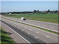
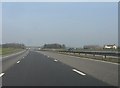
An empty motorway
A spectacularly empty stretch of the M58 as seen from Mercer's Lane. This motorway has been (locally) alleged to be the least used in Britain but that may well be apocryphal.
Image: © Chris Denny
Taken: 20 Jun 2010
0.21 miles
6
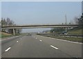
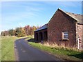
M58 motorway - Brook Farm accommodation bridge
Image: © Peter Whatley
Taken: 23 Mar 2012
0.22 miles
7
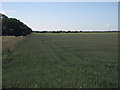
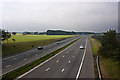
Bradshaw's Plantation, Bickerstaffe
A typical stretch of the featureless farmland of this intensively cultivated part of West Lancashire. The plantation, also typical of this area, is to the left.
Image: © Chris Denny
Taken: 20 Jun 2010
0.23 miles
8
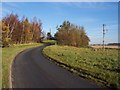
Mercer's Lane passes phone mast near M58 bridge
Image: © Raymond Knapman
Taken: 15 Nov 2010
0.24 miles